Strengen geodata
Strengen (Tyrol) is a seat of a third-order administrative division; located in Austria in Europe/Vienna (GMT+2) time zone. With population of 1,213 people, there are 1035 cities with bigger population in this country. Compared to other cities in Austria, 77.6% of cities are located further ↑North; 96.1% of cities are located further →East and 94.7% of cities have lower elevation than Strengen. Note1


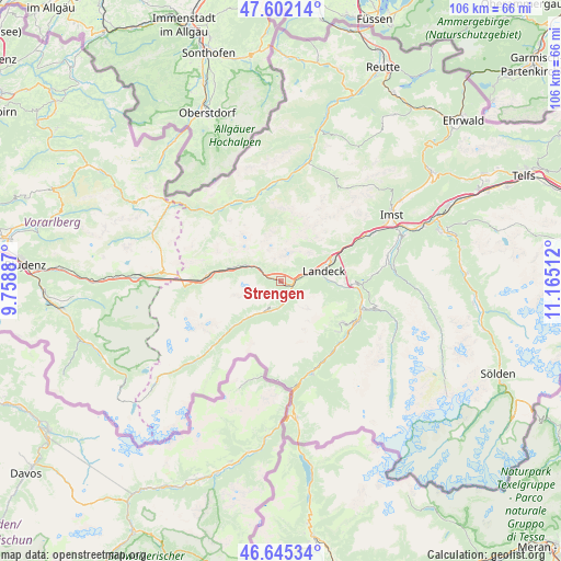
Strengen GPS coordinates[2]
47° 7' 33.204" North, 10° 27' 43.164" East
| Map corner | latitude | longitude |
|---|---|---|
| Upper-left | 47.60214°, | 9.75887° |
| Center: | 47.12589°, | 10.46199° |
| Lower-right: | 46.64534°, | 11.16512° |
| Map W x H: | 106.4×106.4 km | = 66.1×66.1mi |
| max Lat: | 48.98333° ⇑77.6% North |
| Strengen: | 47.12589° |
| min Lat: | ⇓22.4% South 46.48841° |
| min Long | Strengen | max Long |
| 9.57802° | 10.46199° | 17.1° |
| W 3.9%⇐ | ⇒96.1% E |
Elevation
Elevation of Strengen is 1011 m = 3317 ft, and this is 505.5 m = 1658 ft above average elevation for this country.
| Max E: |
2140 m = 7021 ft | 5.3% |
| Strengen | 1011 m 3317 ft | |
| Avg. | 505.5 m = 1658 ft | |
Min E: |
118 m = 387 ft | 94.7% |
See also: Austria elevation on elevation.city.
Geographical zone
Strengen is located in North temperate zone (between Tropic of Cancer and the Arctic Circle). Distance of this North polar circle is 2161.3 km =1343 mi to North.| Distance of | km | miles | from Strengen |
|---|---|---|---|
| North Pole | 4767.2 | 2962.2 | to North |
| Arctic Circle | 2161.3 | 1343 | to North |
| Tropic Cancer | 2634 | 1636.7 | to South |
| Equator | 5239.9 | 3255.9 | to South |


Nearby cities:
15 places around Strengen: (largest is in red/bold)
• Fiss
14 km =8.7 mi,  123°
123°
• Fliess
11.7 km =7.3 mi,  95°
95°
• Flirsch
5.4 km =3.4 mi,  299°
299°
• Grins
4.3 km =2.7 mi,  67°
67°
• Kappl
8.9 km =5.5 mi,  222°
222°
• Landeck
8 km =5 mi,  78°
78°
• Pettneu
9.7 km =6 mi,  283°
283°
• Pians
3.9 km =2.4 mi, 75°
• Sankt Jakob
13 km =8.1 mi, 277°
• See
4.7 km =2.9 mi,  175°
175°
• Serfaus
14.3 km =8.9 mi,  131°
131°
• St Anton am Arlberg
15 km =9.3 mi,  270°
270°
• Stanz bei Landeck
7.3 km =4.5 mi, 70°
• Tobadill
3.9 km =2.4 mi,  91°
91°
• Zams
10.3 km =6.4 mi, 69°
Sources, notices
• [Note1] Compared only with cities in Austria existing in our database
• [Src1] Map data: © OpenStreetMap contributors (CC-BY-SA)
• [Src2] Other city data from geonames.org with taken over terms of usage.
• [Src3] Geographical zone / Annual Mean Temperature by Robert A. Rohde @ Wikipedia
