Tobadill geodata
Tobadill (Tyrol) is a seat of a third-order administrative division; located in Austria in Europe/Vienna (GMT+2) time zone. With population of 516 people, there are 2447 cities with bigger population in this country. Compared to other cities in Austria, 77.6% of cities are located further ↑North; 95.9% of cities are located further →East and 97.6% of cities have lower elevation than Tobadill. Note1


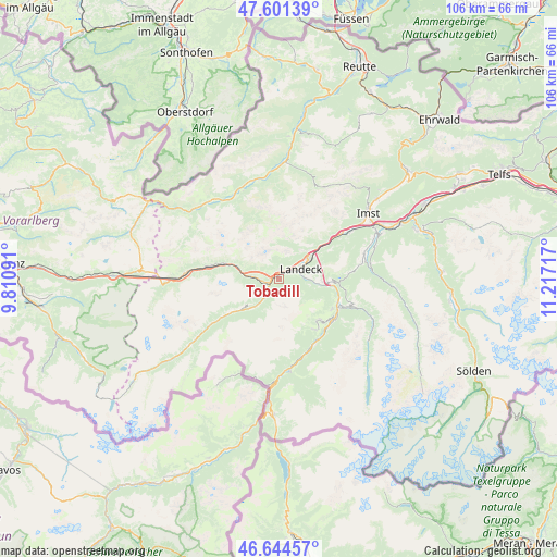
Tobadill GPS coordinates[2]
47° 7' 30.468" North, 10° 30' 50.544" East
| Map corner | latitude | longitude |
|---|---|---|
| Upper-left | 47.60139°, | 9.81091° |
| Center: | 47.12513°, | 10.51404° |
| Lower-right: | 46.64457°, | 11.21717° |
| Map W x H: | 106.4×106.4 km | = 66.1×66.1mi |
| max Lat: | 48.98333° ⇑77.6% North |
| Tobadill: | 47.12513° |
| min Lat: | ⇓22.4% South 46.48841° |
| min Long | Tobadill | max Long |
| 9.57802° | 10.51404° | 17.1° |
| W 4.1%⇐ | ⇒95.9% E |
Elevation
Elevation of Tobadill is 1163 m = 3816 ft, and this is 657.5 m = 2157 ft above average elevation for this country.
| Max E: |
2140 m = 7021 ft | 2.4% |
| Tobadill | 1163 m 3816 ft | |
| Avg. | 505.5 m = 1658 ft | |
Min E: |
118 m = 387 ft | 97.6% |
See also: Austria elevation on elevation.city.
Geographical zone
Tobadill is located in North temperate zone (between Tropic of Cancer and the Arctic Circle). Distance of this North polar circle is 2161.4 km =1343 mi to North.| Distance of | km | miles | from Tobadill |
|---|---|---|---|
| North Pole | 4767.2 | 2962.2 | to North |
| Arctic Circle | 2161.4 | 1343 | to North |
| Tropic Cancer | 2633.9 | 1636.6 | to South |
| Equator | 5239.8 | 3255.9 | to South |


Nearby cities:
15 places around Tobadill: (largest is in red/bold)
• Fiss
10.9 km =6.8 mi,  133°
133°
• Fliess
7.8 km =4.8 mi,  96°
96°
• Flirsch
9.1 km =5.7 mi,  287°
287°
• Grins
1.7 km =1.1 mi,  0°
0°
• Kappl
11.8 km =7.3 mi,  236°
236°
• Ladis
11.7 km =7.3 mi,  118°
118°
• Landeck
4.3 km =2.7 mi,  67°
67°
• Pians
1.1 km =0.7 mi,  353°
353°
• Prutz
12.5 km =7.8 mi,  111°
111°
• Ried im Oberinntal
13.3 km =8.3 mi, 129°
• See
5.9 km =3.7 mi,  217°
217°
• Serfaus
11.6 km =7.2 mi,  144°
144°
• Stanz bei Landeck
3.9 km =2.4 mi,  50°
50°
• Strengen
3.9 km =2.4 mi,  271°
271°
• Zams
6.8 km =4.2 mi,  57°
57°
Sources, notices
• [Note1] Compared only with cities in Austria existing in our database
• [Src1] Map data: © OpenStreetMap contributors (CC-BY-SA)
• [Src2] Other city data from geonames.org with taken over terms of usage.
• [Src3] Geographical zone / Annual Mean Temperature by Robert A. Rohde @ Wikipedia
