Reichersberg geodata
Reichersberg (Upper Austria) is a populated place; located in Austria in Europe/Vienna (GMT+2) time zone. With population of 731 people, there are 1771 cities with bigger population in this country. Compared to other cities in Austria, 87.7% of cities are located further ↓South; 77.1% of cities are located further →East and 66.1% of cities have higher elevation than Reichersberg. Note1
Administrative division(s):
- Level 1: Upper Austria
- Level 2: Politischer Bezirk Ried im Innkreis
- Level 3: Reichersberg


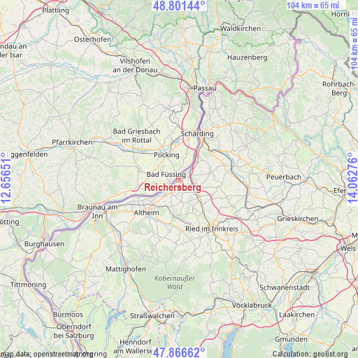
Reichersberg GPS coordinates[2]
48° 20' 10.212" North, 13° 21' 34.668" East
| Map corner | latitude | longitude |
|---|---|---|
| Upper-left | 48.80144°, | 12.65651° |
| Center: | 48.33617°, | 13.35963° |
| Lower-right: | 47.86662°, | 14.06276° |
| Map W x H: | 103.9×103.9 km | = 64.6×64.6mi |
| max Lat: | 48.98333° ⇑12.3% North |
| Reichersberg: | 48.33617° |
| min Lat: | ⇓87.7% South 46.48841° |
| min Long | Reichersberg | max Long |
| 9.57802° | 13.35963° | 17.1° |
| W 22.9%⇐ | ⇒77.1% E |
Elevation
Elevation of Reichersberg is 348 m = 1142 ft, and this is 157.5 m = 517 ft below average elevation for this country.
| Max E: |
2140 m = 7021 ft | 66.1% |
| Avg. | 505.5 m = 1658 ft | |
| Reichersberg | 348 m = 1142 ft | |
Min E: |
118 m = 387 ft | 33.9% |
See also: Austria elevation on elevation.city.
Geographical zone
Reichersberg is located in North temperate zone (between Tropic of Cancer and the Arctic Circle). Distance of this North polar circle is 2026.7 km =1259.3 mi to North.| Distance of | km | miles | from Reichersberg |
|---|---|---|---|
| North Pole | 4632.6 | 2878.6 | to North |
| Arctic Circle | 2026.7 | 1259.3 | to North |
| Tropic Cancer | 2768.6 | 1720.3 | to South |
| Equator | 5374.5 | 3339.6 | to South |


Nearby cities:
15 places around Reichersberg: (largest is in red/bold)
• Antiesenhofen
3.1 km =1.9 mi,  71°
71°
• Aurolzmünster
12.1 km =7.5 mi,  144°
144°
• Diesseits
7.4 km =4.6 mi,  131°
131°
• Forchtenau
10.5 km =6.5 mi, 139°
• Geinberg
9.4 km =5.8 mi,  211°
211°
• Gurten
10.6 km =6.6 mi,  186°
186°
• Obernberg am Inn
2.5 km =1.6 mi,  228°
228°
• Ort im Innkreis
5.9 km =3.7 mi,  111°
111°
• Sankt Georgen bei Obernberg am Inn
5.3 km =3.3 mi,  201°
201°
• Sankt Marienkirchen bei Schärding
8.8 km =5.5 mi,  49°
49°
• Sankt Martin im Innkreis
7.5 km =4.7 mi, 128°
• Suben
9.9 km =6.2 mi,  31°
31°
• Utzenaich
10 km =6.2 mi, 131°
• Weilbach
6.6 km =4.1 mi,  172°
172°
• Wippenham
12.7 km =7.9 mi, 173°
Sources, notices
• [Note1] Compared only with cities in Austria existing in our database
• [Src1] Map data: © OpenStreetMap contributors (CC-BY-SA)
• [Src2] Other city data from geonames.org with taken over terms of usage.
• [Src3] Geographical zone / Annual Mean Temperature by Robert A. Rohde @ Wikipedia
