Wippenham geodata
Wippenham (Upper Austria) is a seat of a third-order administrative division; located in Austria in Europe/Vienna (GMT+2) time zone. With population of 162 people, there are 2888 cities with bigger population in this country. Compared to other cities in Austria, 80.8% of cities are located further ↓South; 76.8% of cities are located further →East and 54.3% of cities have higher elevation than Wippenham. Note1
Administrative division(s):
- Level 1: Upper Austria
- Level 2: Politischer Bezirk Ried im Innkreis
- Level 3: Wippenham


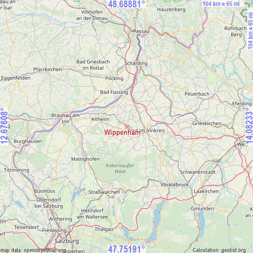
Wippenham GPS coordinates[2]
48° 13' 21" North, 13° 22' 45.12" East
| Map corner | latitude | longitude |
|---|---|---|
| Upper-left | 48.68881°, | 12.67608° |
| Center: | 48.2225°, | 13.3792° |
| Lower-right: | 47.75191°, | 14.08233° |
| Map W x H: | 104.2×104.2 km | = 64.7×64.7mi |
| max Lat: | 48.98333° ⇑19.2% North |
| Wippenham: | 48.2225° |
| min Lat: | ⇓80.8% South 46.48841° |
| min Long | Wippenham | max Long |
| 9.57802° | 13.3792° | 17.1° |
| W 23.2%⇐ | ⇒76.8% E |
Elevation
Elevation of Wippenham is 425 m = 1394 ft, and this is 80.5 m = 264 ft below average elevation for this country.
| Max E: |
2140 m = 7021 ft | 54.3% |
| Avg. | 505.5 m = 1658 ft | |
| Wippenham | 425 m = 1394 ft | |
Min E: |
118 m = 387 ft | 45.7% |
See also: Austria elevation on elevation.city.
Geographical zone
Wippenham is located in North temperate zone (between Tropic of Cancer and the Arctic Circle). Distance of this North polar circle is 2039.3 km =1267.2 mi to North.| Distance of | km | miles | from Wippenham |
|---|---|---|---|
| North Pole | 4645.2 | 2886.4 | to North |
| Arctic Circle | 2039.3 | 1267.2 | to North |
| Tropic Cancer | 2755.9 | 1712.4 | to South |
| Equator | 5361.8 | 3331.7 | to South |


Nearby cities:
15 places around Wippenham: (largest is in red/bold)
• Aspach
6.9 km =4.3 mi,  233°
233°
• Aurolzmünster
6.3 km =3.9 mi,  62°
62°
• Diesseits
8.8 km =5.5 mi,  28°
28°
• Forchtenau
7.1 km =4.4 mi,  49°
49°
• Geinberg
7.8 km =4.8 mi,  306°
306°
• Gurten
3.3 km =2.1 mi, 309°
• Maierhof
6.7 km =4.2 mi,  70°
70°
• Mehrnbach
4.5 km =2.8 mi,  111°
111°
• Neuhofen im Innkreis
7.8 km =4.8 mi,  117°
117°
• Polling im Innkreis
7.4 km =4.6 mi,  277°
277°
• Ried im Innkreis
8.2 km =5.1 mi,  98°
98°
• Sankt Georgen bei Obernberg am Inn
8.4 km =5.2 mi,  336°
336°
• Utzenaich
8.5 km =5.3 mi, 45°
• Weilbach
6.1 km =3.8 mi,  354°
354°
• Wildenau
4.9 km =3 mi,  248°
248°
Sources, notices
• [Note1] Compared only with cities in Austria existing in our database
• [Src1] Map data: © OpenStreetMap contributors (CC-BY-SA)
• [Src2] Other city data from geonames.org with taken over terms of usage.
• [Src3] Geographical zone / Annual Mean Temperature by Robert A. Rohde @ Wikipedia
