Reichenau an der Rax geodata
Reichenau an der Rax (Lower Austria) is a seat of a third-order administrative division; located in Austria in Europe/Vienna (GMT+2) time zone. With population of 1,276 people, there are 991 cities with bigger population in this country. Compared to other cities in Austria, 53.1% of cities are located further ↓South; 75.9% of cities are located further ←West and 54.7% of cities have lower elevation than Reichenau an der Rax. Note1
Administrative division(s):
- Level 1: Lower Austria
- Level 2: Politischer Bezirk Neunkirchen
- Level 3: Reichenau an der Rax


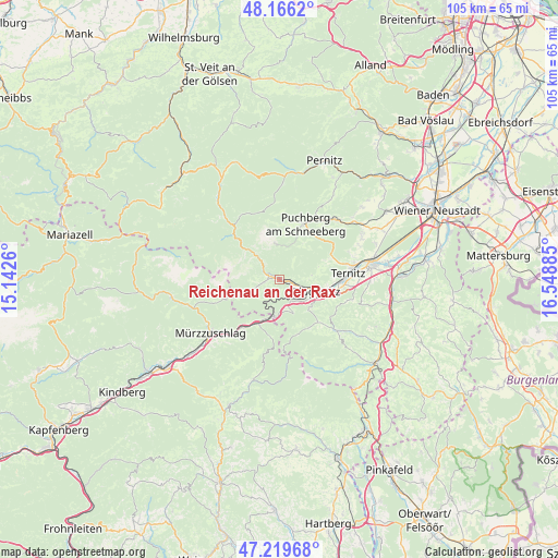
Reichenau an der Rax GPS coordinates[2]
47° 41' 42.324" North, 15° 50' 44.592" East
| Map corner | latitude | longitude |
|---|---|---|
| Upper-left | 48.1662°, | 15.1426° |
| Center: | 47.69509°, | 15.84572° |
| Lower-right: | 47.21968°, | 16.54885° |
| Map W x H: | 105.2×105.2 km | = 65.4×65.4mi |
| max Lat: | 48.98333° ⇑46.9% North |
| Reichenau an der Rax: | 47.69509° |
| min Lat: | ⇓53.1% South 46.48841° |
| min Long | Reichenau an de | max Long |
| 9.57802° | 15.84572° | 17.1° |
| W 75.9%⇐ | ⇒24.1% E |
Elevation
Elevation of Reichenau an der Rax is 482 m = 1581 ft, and this is 23.5 m = 77 ft below average elevation for this country.
| Max E: |
2140 m = 7021 ft | 45.3% |
| Avg. | 505.5 m = 1658 ft | |
| Reichenau an der Rax | 482 m = 1581 ft | |
Min E: |
118 m = 387 ft | 54.7% |
See also: Austria elevation on elevation.city.
Geographical zone
Reichenau an der Rax is located in North temperate zone (between Tropic of Cancer and the Arctic Circle). Distance of this North polar circle is 2098 km =1303.6 mi to North.| Distance of | km | miles | from Reichenau an der Rax |
|---|---|---|---|
| North Pole | 4703.9 | 2922.9 | to North |
| Arctic Circle | 2098 | 1303.6 | to North |
| Tropic Cancer | 2697.3 | 1676 | to South |
| Equator | 5303.2 | 3295.3 | to South |


Nearby cities:
15 places around Reichenau an der Rax: (largest is in red/bold)
• Buchbach
10.4 km =6.5 mi,  89°
89°
• Enzenreith
8.5 km =5.3 mi,  110°
110°
• Gloggnitz
7.3 km =4.5 mi, 107°
• Otterthal
10.9 km =6.8 mi,  143°
143°
• Payerbach
1.4 km =0.9 mi,  104°
104°
• Prigglitz
6.2 km =3.9 mi,  81°
81°
• Puchberg am Schneeberg
11.4 km =7.1 mi,  26°
26°
• Putzmannsdorf
11.3 km =7 mi, 91°
• Raach am Hochgebirge
9.5 km =5.9 mi, 136°
• Schottwien
4.7 km =2.9 mi,  154°
154°
• Semmering
7 km =4.3 mi,  189°
189°
• Spital am Semmering
11.5 km =7.1 mi,  218°
218°
• Steinhaus am Semmering
9.4 km =5.8 mi,  201°
201°
• Stuppach
9 km =5.6 mi, 100°
• Trattenbach
10.7 km =6.6 mi,  171°
171°
Sources, notices
• [Note1] Compared only with cities in Austria existing in our database
• [Src1] Map data: © OpenStreetMap contributors (CC-BY-SA)
• [Src2] Other city data from geonames.org with taken over terms of usage.
• [Src3] Geographical zone / Annual Mean Temperature by Robert A. Rohde @ Wikipedia
