Payerbach geodata
Payerbach (Lower Austria) is a seat of a third-order administrative division; located in Austria in Europe/Vienna (GMT+2) time zone. With population of 1,093 people, there are 1169 cities with bigger population in this country. Compared to other cities in Austria, 53% of cities are located further ↓South; 76.4% of cities are located further ←West and 53.2% of cities have lower elevation than Payerbach. Note1
Administrative division(s):
- Level 1: Lower Austria
- Level 2: Politischer Bezirk Neunkirchen
- Level 3: Payerbach


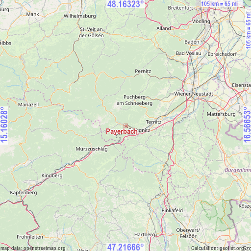
Payerbach GPS coordinates[2]
47° 41' 31.524" North, 15° 51' 48.24" East
| Map corner | latitude | longitude |
|---|---|---|
| Upper-left | 48.16323°, | 15.16028° |
| Center: | 47.69209°, | 15.8634° |
| Lower-right: | 47.21666°, | 16.56653° |
| Map W x H: | 105.2×105.2 km | = 65.4×65.4mi |
| max Lat: | 48.98333° ⇑47% North |
| Payerbach: | 47.69209° |
| min Lat: | ⇓53% South 46.48841° |
| min Long | Payerbach | max Long |
| 9.57802° | 15.8634° | 17.1° |
| W 76.4%⇐ | ⇒23.6% E |
Elevation
Elevation of Payerbach is 473 m = 1552 ft, and this is 32.5 m = 107 ft below average elevation for this country.
| Max E: |
2140 m = 7021 ft | 46.8% |
| Avg. | 505.5 m = 1658 ft | |
| Payerbach | 473 m = 1552 ft | |
Min E: |
118 m = 387 ft | 53.2% |
See also: Austria elevation on elevation.city.
Geographical zone
Payerbach is located in North temperate zone (between Tropic of Cancer and the Arctic Circle). Distance of this North polar circle is 2098.3 km =1303.8 mi to North.| Distance of | km | miles | from Payerbach |
|---|---|---|---|
| North Pole | 4704.2 | 2923.1 | to North |
| Arctic Circle | 2098.3 | 1303.8 | to North |
| Tropic Cancer | 2696.9 | 1675.8 | to South |
| Equator | 5302.9 | 3295.1 | to South |


Nearby cities:
15 places around Payerbach: (largest is in red/bold)
• Buchbach
9.1 km =5.7 mi,  86°
86°
• Enzenreith
7.2 km =4.5 mi,  111°
111°
• Gloggnitz
6 km =3.7 mi, 108°
• Grafenbach
10.9 km =6.8 mi,  97°
97°
• Otterthal
9.9 km =6.2 mi,  148°
148°
• Pottschach
10.8 km =6.7 mi, 86°
• Prigglitz
5 km =3.1 mi,  75°
75°
• Putzmannsdorf
10 km =6.2 mi, 90°
• Raach am Hochgebirge
8.4 km =5.2 mi,  141°
141°
• Reichenau an der Rax
1.4 km =0.9 mi,  284°
284°
• Schottwien
4 km =2.5 mi,  170°
170°
• Semmering
7 km =4.3 mi,  201°
201°
• Steinhaus am Semmering
9.6 km =6 mi,  209°
209°
• Stuppach
7.7 km =4.8 mi, 99°
• Trattenbach
10.2 km =6.3 mi,  178°
178°
Sources, notices
• [Note1] Compared only with cities in Austria existing in our database
• [Src1] Map data: © OpenStreetMap contributors (CC-BY-SA)
• [Src2] Other city data from geonames.org with taken over terms of usage.
• [Src3] Geographical zone / Annual Mean Temperature by Robert A. Rohde @ Wikipedia
