Heissingfelding geodata
Heissingfelding (Salzburg) is a populated place; located in Austria in Europe/Vienna (GMT+2) time zone. With population of 716 people, there are 1815 cities with bigger population in this country. Compared to other cities in Austria, 75% of cities are located further ↑North; 81.1% of cities are located further →East and 88% of cities have lower elevation than Heissingfelding. Note1
Administrative division(s):
- Level 1: Salzburg
- Level 2: Politischer Bezirk Sankt Johann im Pongau
- Level 3: Bad Hofgastein


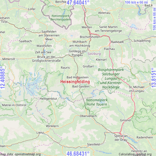
Heissingfelding GPS coordinates[2]
47° 9' 52.236" North, 13° 6' 43.092" East
| Map corner | latitude | longitude |
|---|---|---|
| Upper-left | 47.64041°, | 12.40885° |
| Center: | 47.16451°, | 13.11197° |
| Lower-right: | 46.68431°, | 13.8151° |
| Map W x H: | 106.3×106.3 km | = 66.1×66.1mi |
| max Lat: | 48.98333° ⇑75% North |
| Heissingfelding: | 47.16451° |
| min Lat: | ⇓25% South 46.48841° |
| min Long | Heissingfelding | max Long |
| 9.57802° | 13.11197° | 17.1° |
| W 18.9%⇐ | ⇒81.1% E |
Elevation
Elevation of Heissingfelding is 844 m = 2769 ft, and this is 338.5 m = 1111 ft above average elevation for this country.
| Max E: |
2140 m = 7021 ft | 12% |
| Heissingfelding | 844 m 2769 ft | |
| Avg. | 505.5 m = 1658 ft | |
Min E: |
118 m = 387 ft | 88% |
See also: Austria elevation on elevation.city.
Geographical zone
Heissingfelding is located in North temperate zone (between Tropic of Cancer and the Arctic Circle). Distance of this North polar circle is 2157 km =1340.3 mi to North.| Distance of | km | miles | from Heissingfelding |
|---|---|---|---|
| North Pole | 4762.9 | 2959.5 | to North |
| Arctic Circle | 2157 | 1340.3 | to North |
| Tropic Cancer | 2638.3 | 1639.4 | to South |
| Equator | 5244.2 | 3258.6 | to South |


Nearby cities:
15 places around Heissingfelding: (largest is in red/bold)
• Anger
1.1 km =0.7 mi,  205°
205°
• Bad Gastein
5.7 km =3.5 mi,  162°
162°
• Bad Hofgastein
1.4 km =0.9 mi,  312°
312°
• Dorfgastein
8.6 km =5.3 mi,  355°
355°
• Goldegg
17.2 km =10.7 mi, 356°
• Grossarl
10.1 km =6.3 mi,  40°
40°
• Hüttschlag
9.2 km =5.7 mi,  81°
81°
• Lend
15.6 km =9.7 mi,  343°
343°
• Plankenau
19 km =11.8 mi,  18°
18°
• Rauris
11.2 km =7 mi, 307°
• Sankt Veit im Pongau
19 km =11.8 mi,  8°
8°
• Schwarzach im Pongau
17.6 km =10.9 mi, 9°
• Taxenbach
18.1 km =11.2 mi,  321°
321°
• Vorderschneeberg
2.3 km =1.4 mi,  186°
186°
• Wörtherberg
10.9 km =6.8 mi,  297°
297°
Sources, notices
• [Note1] Compared only with cities in Austria existing in our database
• [Src1] Map data: © OpenStreetMap contributors (CC-BY-SA)
• [Src2] Other city data from geonames.org with taken over terms of usage.
• [Src3] Geographical zone / Annual Mean Temperature by Robert A. Rohde @ Wikipedia
