Ratschendorf geodata
Ratschendorf (Styria) is a seat of a third-order administrative division; located in Austria in Europe/Vienna (GMT+2) time zone. With population of 601 people, there are 2139 cities with bigger population in this country. Compared to other cities in Austria, 93.9% of cities are located further ↑North; 75.1% of cities are located further ←West and 85.8% of cities have higher elevation than Ratschendorf. Note1
Administrative division(s):
- Level 1: Styria
- Level 2: Politischer Bezirk Südoststeiermark
- Level 3: Deutsch Goritz


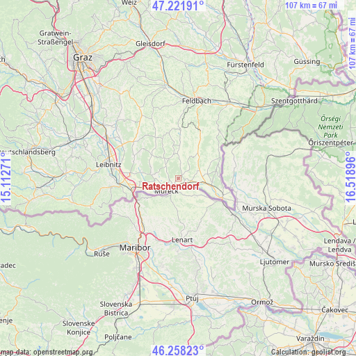
Ratschendorf GPS coordinates[2]
46° 44' 31.992" North, 15° 48' 56.988" East
| Map corner | latitude | longitude |
|---|---|---|
| Upper-left | 47.22191°, | 15.11271° |
| Center: | 46.74222°, | 15.81583° |
| Lower-right: | 46.25823°, | 16.51896° |
| Map W x H: | 107.2×107.1 km | = 66.6×66.5mi |
| max Lat: | 48.98333° ⇑93.9% North |
| Ratschendorf: | 46.74222° |
| min Lat: | ⇓6.1% South 46.48841° |
| min Long | Ratschendorf | max Long |
| 9.57802° | 15.81583° | 17.1° |
| W 75.1%⇐ | ⇒24.9% E |
Elevation
Elevation of Ratschendorf is 243 m = 797 ft, and this is 262.5 m = 861 ft below average elevation for this country.
| Max E: |
2140 m = 7021 ft | 85.8% |
| Avg. | 505.5 m = 1658 ft | |
| Ratschendorf | 243 m = 797 ft | |
Min E: |
118 m = 387 ft | 14.2% |
See also: Austria elevation on elevation.city.
Geographical zone
Ratschendorf is located in North temperate zone (between Tropic of Cancer and the Arctic Circle). Distance of this North polar circle is 2203.9 km =1369.4 mi to North.| Distance of | km | miles | from Ratschendorf |
|---|---|---|---|
| North Pole | 4809.8 | 2988.7 | to North |
| Arctic Circle | 2203.9 | 1369.4 | to North |
| Tropic Cancer | 2591.3 | 1610.2 | to South |
| Equator | 5197.2 | 3229.4 | to South |


Nearby cities:
15 places around Ratschendorf: (largest is in red/bold)
• Bierbaum am Auersbach
9.9 km =6.2 mi,  349°
349°
• Deutsch Goritz
1.4 km =0.9 mi,  47°
47°
• Dietersdorf am Gnasbach
7.5 km =4.7 mi,  357°
357°
• Eichfeld
4.1 km =2.5 mi,  242°
242°
• Gosdorf
2.4 km =1.5 mi,  227°
227°
• Halbenrain
10.2 km =6.3 mi,  102°
102°
• Mettersdorf am Saßbach
10.7 km =6.6 mi,  311°
311°
• Mureck
4.9 km =3 mi,  219°
219°
• Sankt Peter am Ottersbach
7.5 km =4.7 mi,  325°
325°
• Stainz bei Straden
10.8 km =6.7 mi,  32°
32°
• Straden
8.4 km =5.2 mi, 28°
• Tieschen
10.8 km =6.7 mi,  63°
63°
• Trössing
8.3 km =5.2 mi,  0°
0°
• Weinburg am Saßbach
7.3 km =4.5 mi,  279°
279°
• Weitersfeld an der Mur
8.9 km =5.5 mi, 238°
Sources, notices
• [Note1] Compared only with cities in Austria existing in our database
• [Src1] Map data: © OpenStreetMap contributors (CC-BY-SA)
• [Src2] Other city data from geonames.org with taken over terms of usage.
• [Src3] Geographical zone / Annual Mean Temperature by Robert A. Rohde @ Wikipedia
