Rassach geodata
Rassach (Styria) is a seat of a third-order administrative division; located in Austria in Europe/Vienna (GMT+2) time zone. With population of 333 people, there are 2703 cities with bigger population in this country. Compared to other cities in Austria, 89.3% of cities are located further ↑North; 59.4% of cities are located further ←West and 60.1% of cities have higher elevation than Rassach. Note1
Administrative division(s):
- Level 1: Styria
- Level 2: Politischer Bezirk Deutschlandsberg
- Level 3: Stainz


Rassach GPS coordinates[2]
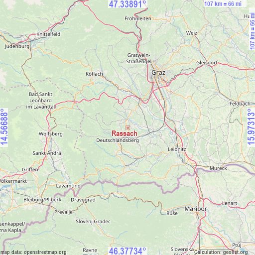
46° 51' 37.008" North, 15° 16' 12" East
| Map corner | latitude | longitude |
|---|---|---|
| Upper-left | 47.33891°, | 14.56688° |
| Center: | 46.86028°, | 15.27° |
| Lower-right: | 46.37734°, | 15.97313° |
| Map W x H: | 106.9×106.9 km | = 66.4×66.4mi |
| max Lat: | 48.98333° ⇑89.3% North |
| Rassach: | 46.86028° |
| min Lat: | ⇓10.7% South 46.48841° |
| min Long | Rassach | max Long |
| 9.57802° | 15.27° | 17.1° |
| W 59.4%⇐ | ⇒40.6% E |
Elevation
Elevation of Rassach is 382 m = 1253 ft, and this is 123.5 m = 405 ft below average elevation for this country.
| Max E: |
2140 m = 7021 ft | 60.1% |
| Avg. | 505.5 m = 1658 ft | |
| Rassach | 382 m = 1253 ft | |
Min E: |
118 m = 387 ft | 39.9% |
See also: Austria elevation on elevation.city.
Geographical zone
Rassach is located in North temperate zone (between Tropic of Cancer and the Arctic Circle). Distance of this North polar circle is 2190.8 km =1361.3 mi to North.| Distance of | km | miles | from Rassach |
|---|---|---|---|
| North Pole | 4796.7 | 2980.5 | to North |
| Arctic Circle | 2190.8 | 1361.3 | to North |
| Tropic Cancer | 2604.5 | 1618.4 | to South |
| Equator | 5210.4 | 3237.6 | to South |


Nearby cities:
15 places around Rassach: (largest is in red/bold)
• Bad Gams
3.6 km =2.2 mi,  289°
289°
• Deutschlandsberg
6.2 km =3.9 mi,  215°
215°
• Freidorf an der Laßnitz
5.1 km =3.2 mi,  197°
197°
• Graschuh
2.4 km =1.5 mi,  8°
8°
• Greisdorf
8.3 km =5.2 mi,  332°
332°
• Groß Sankt Florian
5.4 km =3.4 mi,  137°
137°
• Hollenegg
8.8 km =5.5 mi,  209°
209°
• Kothvogel
2.7 km =1.7 mi,  319°
319°
• Lassnitz
5.1 km =3.2 mi, 197°
• Pichling bei Stainz
5 km =3.1 mi, 7°
• Sankt Josef (Weststeiermark)
7.4 km =4.6 mi,  42°
42°
• Sankt Stefan ob Stainz
7.6 km =4.7 mi,  353°
353°
• Stainz
3.8 km =2.4 mi,  356°
356°
• Stallhof
2.8 km =1.7 mi,  21°
21°
• Unterbergla
6.8 km =4.2 mi,  149°
149°
Sources, notices
• [Note1] Compared only with cities in Austria existing in our database
• [Src1] Map data: © OpenStreetMap contributors (CC-BY-SA)
• [Src2] Other city data from geonames.org with taken over terms of usage.
• [Src3] Geographical zone / Annual Mean Temperature by Robert A. Rohde @ Wikipedia
