Randegg geodata
Randegg (Lower Austria) is a seat of a third-order administrative division; located in Austria in Europe/Vienna (GMT+2) time zone. With population of 326 people, there are 2713 cities with bigger population in this country. Compared to other cities in Austria, 66.9% of cities are located further ↓South; 53.9% of cities are located further ←West and 63.4% of cities have higher elevation than Randegg. Note1
Administrative division(s):
- Level 1: Lower Austria
- Level 2: Politischer Bezirk Scheibbs
- Level 3: Randegg


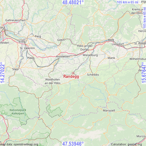
Randegg GPS coordinates[2]
48° 0' 43.128" North, 14° 58' 24.024" East
| Map corner | latitude | longitude |
|---|---|---|
| Upper-left | 48.48021°, | 14.27022° |
| Center: | 48.01198°, | 14.97334° |
| Lower-right: | 47.53946°, | 15.67647° |
| Map W x H: | 104.6×104.6 km | = 65×65mi |
| max Lat: | 48.98333° ⇑33.1% North |
| Randegg: | 48.01198° |
| min Lat: | ⇓66.9% South 46.48841° |
| min Long | Randegg | max Long |
| 9.57802° | 14.97334° | 17.1° |
| W 53.9%⇐ | ⇒46.1% E |
Elevation
Elevation of Randegg is 361 m = 1184 ft, and this is 144.5 m = 474 ft below average elevation for this country.
| Max E: |
2140 m = 7021 ft | 63.4% |
| Avg. | 505.5 m = 1658 ft | |
| Randegg | 361 m = 1184 ft | |
Min E: |
118 m = 387 ft | 36.6% |
See also: Austria elevation on elevation.city.
Geographical zone
Randegg is located in North temperate zone (between Tropic of Cancer and the Arctic Circle). Distance of this North polar circle is 2062.7 km =1281.7 mi to North.| Distance of | km | miles | from Randegg |
|---|---|---|---|
| North Pole | 4668.6 | 2900.9 | to North |
| Arctic Circle | 2062.7 | 1281.7 | to North |
| Tropic Cancer | 2732.5 | 1697.9 | to South |
| Equator | 5338.4 | 3317.1 | to South |


Nearby cities:
15 places around Randegg: (largest is in red/bold)
• Blindenmarkt
12.9 km =8 mi,  4°
4°
• Euratsfeld
8.4 km =5.2 mi,  338°
338°
• Ferschnitz
9.2 km =5.7 mi,  5°
5°
• Gaming
12.6 km =7.8 mi,  137°
137°
• Gresten
4.9 km =3 mi,  127°
127°
• Höfling
6.7 km =4.2 mi,  44°
44°
• Neuhofen an der Ybbs
10.2 km =6.3 mi,  300°
300°
• Purgstall
13.1 km =8.1 mi,  66°
66°
• Reinsberg
7.8 km =4.8 mi,  111°
111°
• Steinakirchen am Forst
8.5 km =5.3 mi, 40°
• Unteramt
5.1 km =3.2 mi, 107°
• Wang
5.4 km =3.4 mi,  46°
46°
• Winklarn
12.8 km =8 mi,  313°
313°
• Wolfpassing
10 km =6.2 mi, 42°
• Ybbsitz
9.4 km =5.8 mi,  220°
220°
Sources, notices
• [Note1] Compared only with cities in Austria existing in our database
• [Src1] Map data: © OpenStreetMap contributors (CC-BY-SA)
• [Src2] Other city data from geonames.org with taken over terms of usage.
• [Src3] Geographical zone / Annual Mean Temperature by Robert A. Rohde @ Wikipedia
