Rainfeld geodata
Rainfeld (Lower Austria) is a populated place; located in Austria in Europe/Vienna (GMT+2) time zone. With population of 816 people, there are 1583 cities with bigger population in this country. Compared to other cities in Austria, 69.4% of cities are located further ↓South; 72.4% of cities are located further ←West and 60.1% of cities have higher elevation than Rainfeld. Note1
Administrative division(s):
- Level 1: Lower Austria
- Level 2: Politischer Bezirk Lilienfeld
- Level 3: Sankt Veit an der Gölsen


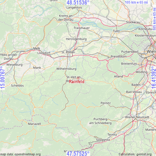
Rainfeld GPS coordinates[2]
48° 2' 50.82" North, 15° 42' 38.844" East
| Map corner | latitude | longitude |
|---|---|---|
| Upper-left | 48.51536°, | 15.00767° |
| Center: | 48.04745°, | 15.71079° |
| Lower-right: | 47.57525°, | 16.41392° |
| Map W x H: | 104.5×104.5 km | = 64.9×64.9mi |
| max Lat: | 48.98333° ⇑30.6% North |
| Rainfeld: | 48.04745° |
| min Lat: | ⇓69.4% South 46.48841° |
| min Long | Rainfeld | max Long |
| 9.57802° | 15.71079° | 17.1° |
| W 72.4%⇐ | ⇒27.6% E |
Elevation
Elevation of Rainfeld is 382 m = 1253 ft, and this is 123.5 m = 405 ft below average elevation for this country.
| Max E: |
2140 m = 7021 ft | 60.1% |
| Avg. | 505.5 m = 1658 ft | |
| Rainfeld | 382 m = 1253 ft | |
Min E: |
118 m = 387 ft | 39.9% |
See also: Austria elevation on elevation.city.
Geographical zone
Rainfeld is located in North temperate zone (between Tropic of Cancer and the Arctic Circle). Distance of this North polar circle is 2058.8 km =1279.3 mi to North.| Distance of | km | miles | from Rainfeld |
|---|---|---|---|
| North Pole | 4664.7 | 2898.5 | to North |
| Arctic Circle | 2058.8 | 1279.3 | to North |
| Tropic Cancer | 2736.5 | 1700.4 | to South |
| Equator | 5342.4 | 3319.6 | to South |


Nearby cities:
15 places around Rainfeld: (largest is in red/bold)
• Eschenau
10.7 km =6.6 mi,  270°
270°
• Gölsen
2.5 km =1.6 mi,  104°
104°
• Hainfeld
4.9 km =3 mi,  107°
107°
• Kleinzell
7.7 km =4.8 mi,  165°
165°
• Lilienfeld
9.3 km =5.8 mi,  245°
245°
• Marktl
8.5 km =5.3 mi, 251°
• Ramsau
8.5 km =5.3 mi,  125°
125°
• Rohrbach an der Gölsen
2.3 km =1.4 mi,  91°
91°
• Rotheau
8.7 km =5.4 mi,  285°
285°
• Sankt Veit an der Gölsen
3.1 km =1.9 mi,  261°
261°
• Stangental
10.6 km =6.6 mi, 246°
• Steinwandleiten
6.1 km =3.8 mi, 290°
• Stössing
11.3 km =7 mi,  42°
42°
• Traisen
8.4 km =5.2 mi, 259°
• Wilhelmsburg
10.2 km =6.3 mi,  309°
309°
Sources, notices
• [Note1] Compared only with cities in Austria existing in our database
• [Src1] Map data: © OpenStreetMap contributors (CC-BY-SA)
• [Src2] Other city data from geonames.org with taken over terms of usage.
• [Src3] Geographical zone / Annual Mean Temperature by Robert A. Rohde @ Wikipedia
