Ramsau geodata
Ramsau (Lower Austria) is a seat of a third-order administrative division; located in Austria in Europe/Vienna (GMT+2) time zone. With population of 635 people, there are 2021 cities with bigger population in this country. Compared to other cities in Austria, 66.4% of cities are located further ↓South; 74.8% of cities are located further ←West and 52.1% of cities have lower elevation than Ramsau. Note1
Administrative division(s):
- Level 1: Lower Austria
- Level 2: Politischer Bezirk Lilienfeld
- Level 3: Ramsau


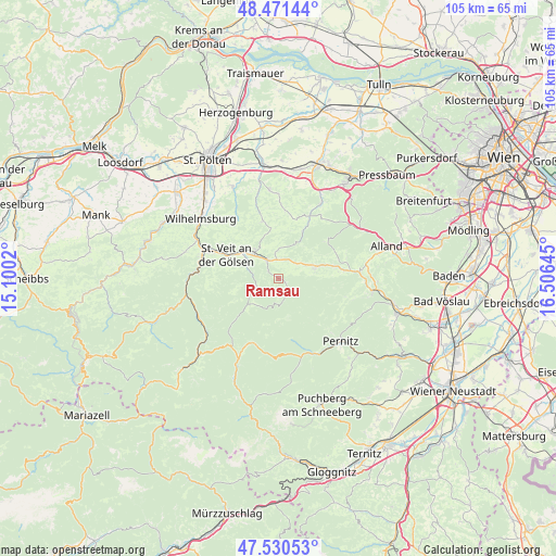
Ramsau GPS coordinates[2]
48° 0' 11.268" North, 15° 48' 11.952" East
| Map corner | latitude | longitude |
|---|---|---|
| Upper-left | 48.47144°, | 15.1002° |
| Center: | 48.00313°, | 15.80332° |
| Lower-right: | 47.53053°, | 16.50645° |
| Map W x H: | 104.6×104.6 km | = 65×65mi |
| max Lat: | 48.98333° ⇑33.6% North |
| Ramsau: | 48.00313° |
| min Lat: | ⇓66.4% South 46.48841° |
| min Long | Ramsau | max Long |
| 9.57802° | 15.80332° | 17.1° |
| W 74.8%⇐ | ⇒25.2% E |
Elevation
Elevation of Ramsau is 466 m = 1529 ft, and this is 39.5 m = 130 ft below average elevation for this country.
| Max E: |
2140 m = 7021 ft | 47.9% |
| Avg. | 505.5 m = 1658 ft | |
| Ramsau | 466 m = 1529 ft | |
Min E: |
118 m = 387 ft | 52.1% |
See also: Austria elevation on elevation.city.
Geographical zone
Ramsau is located in North temperate zone (between Tropic of Cancer and the Arctic Circle). Distance of this North polar circle is 2063.7 km =1282.3 mi to North.| Distance of | km | miles | from Ramsau |
|---|---|---|---|
| North Pole | 4669.6 | 2901.6 | to North |
| Arctic Circle | 2063.7 | 1282.3 | to North |
| Tropic Cancer | 2731.5 | 1697.3 | to South |
| Equator | 5337.4 | 3316.5 | to South |


Nearby cities:
15 places around Ramsau: (largest is in red/bold)
• Altenmarkt an der Triesting
14.4 km =8.9 mi,  84°
84°
• Furth an der Triesting
13.1 km =8.1 mi,  104°
104°
• Gölsen
6.2 km =3.9 mi,  314°
314°
• Hainfeld
4.1 km =2.5 mi,  327°
327°
• Kaumberg
7.4 km =4.6 mi,  71°
71°
• Kleinzell
5.6 km =3.5 mi,  242°
242°
• Marktl
15.1 km =9.4 mi,  278°
278°
• Muggendorf
14.2 km =8.8 mi,  136°
136°
• Rainfeld
8.5 km =5.3 mi, 305°
• Rohr im Gebirge
13.1 km =8.1 mi,  202°
202°
• Rohrbach an der Gölsen
6.7 km =4.2 mi,  316°
316°
• Sankt Veit an der Gölsen
10.9 km =6.8 mi,  294°
294°
• Steinwandleiten
14.5 km =9 mi,  299°
299°
• Stössing
13.3 km =8.3 mi,  3°
3°
• Thenneberg
12.2 km =7.6 mi, 82°
Sources, notices
• [Note1] Compared only with cities in Austria existing in our database
• [Src1] Map data: © OpenStreetMap contributors (CC-BY-SA)
• [Src2] Other city data from geonames.org with taken over terms of usage.
• [Src3] Geographical zone / Annual Mean Temperature by Robert A. Rohde @ Wikipedia
