Palt geodata
Palt (Lower Austria) is a populated place; located in Austria in Europe/Vienna (GMT+2) time zone. With population of 764 people, there are 1694 cities with bigger population in this country. Compared to other cities in Austria, 90.1% of cities are located further ↓South; 69% of cities are located further ←West and 91.7% of cities have higher elevation than Palt. Note1
Administrative division(s):
- Level 1: Lower Austria
- Level 2: Politischer Bezirk Krems
- Level 3: Furth bei Göttweig


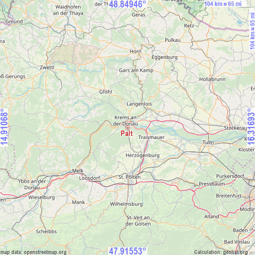
Palt GPS coordinates[2]
48° 23' 4.704" North, 15° 36' 49.68" East
| Map corner | latitude | longitude |
|---|---|---|
| Upper-left | 48.84946°, | 14.91068° |
| Center: | 48.38464°, | 15.6138° |
| Lower-right: | 47.91553°, | 16.31693° |
| Map W x H: | 103.8×103.8 km | = 64.5×64.5mi |
| max Lat: | 48.98333° ⇑9.9% North |
| Palt: | 48.38464° |
| min Lat: | ⇓90.1% South 46.48841° |
| min Long | Palt | max Long |
| 9.57802° | 15.6138° | 17.1° |
| W 69%⇐ | ⇒31% E |
Elevation
Elevation of Palt is 203 m = 666 ft, and this is 302.5 m = 992 ft below average elevation for this country.
| Max E: |
2140 m = 7021 ft | 91.7% |
| Avg. | 505.5 m = 1658 ft | |
| Palt | 203 m = 666 ft | |
Min E: |
118 m = 387 ft | 8.3% |
See also: Austria elevation on elevation.city.
Geographical zone
Palt is located in North temperate zone (between Tropic of Cancer and the Arctic Circle). Distance of this North polar circle is 2021.3 km =1256 mi to North.| Distance of | km | miles | from Palt |
|---|---|---|---|
| North Pole | 4627.2 | 2875.2 | to North |
| Arctic Circle | 2021.3 | 1256 | to North |
| Tropic Cancer | 2773.9 | 1723.6 | to South |
| Equator | 5379.9 | 3342.9 | to South |


Nearby cities:
15 places around Palt: (largest is in red/bold)
• Egelsee
5.3 km =3.3 mi,  313°
313°
• Furth bei Göttweig
1.2 km =0.7 mi,  179°
179°
• Gneixendorf
5.9 km =3.7 mi,  3°
3°
• Krems an der Donau
2.7 km =1.7 mi, 0°
• Landersdorf
3.8 km =2.4 mi,  22°
22°
• Lerchenfeld
3.4 km =2.1 mi, 23°
• Mautern
2.8 km =1.7 mi,  289°
289°
• Nussdorf ob der Traisen
7 km =4.3 mi,  120°
120°
• Paudorf
3.4 km =2.1 mi,  174°
174°
• Rehberg
5.5 km =3.4 mi,  339°
339°
• Rohrendorf bei Krems
5 km =3.1 mi,  40°
40°
• Stein an der Donau
3.1 km =1.9 mi, 307°
• Theiss
5.9 km =3.7 mi,  75°
75°
• Unterbergern
5.1 km =3.2 mi,  247°
247°
• Weinzierl bei Krems
2 km =1.2 mi,  329°
329°
Sources, notices
• [Note1] Compared only with cities in Austria existing in our database
• [Src1] Map data: © OpenStreetMap contributors (CC-BY-SA)
• [Src2] Other city data from geonames.org with taken over terms of usage.
• [Src3] Geographical zone / Annual Mean Temperature by Robert A. Rohde @ Wikipedia
