Oetz geodata
Oetz (Tyrol) is a seat of a third-order administrative division; located in Austria in Europe/Vienna (GMT+2) time zone. With population of 2,402 people, there are 504 cities with bigger population in this country. Compared to other cities in Austria, 73% of cities are located further ↑North; 94.1% of cities are located further →East and 84.3% of cities have lower elevation than Oetz. Note1


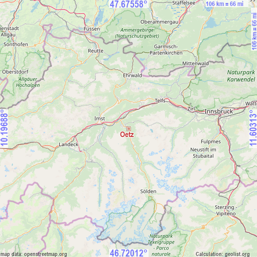
Oetz GPS coordinates[2]
47° 12' 0" North, 10° 54' 0" East
| Map corner | latitude | longitude |
|---|---|---|
| Upper-left | 47.67558°, | 10.19688° |
| Center: | 47.2°, | 10.9° |
| Lower-right: | 46.72012°, | 11.60313° |
| Map W x H: | 106.2×106.2 km | = 66×66mi |
| max Lat: | 48.98333° ⇑73% North |
| Oetz: | 47.2° |
| min Lat: | ⇓27% South 46.48841° |
| min Long | Oetz | max Long |
| 9.57802° | 10.9° | 17.1° |
| W 5.9%⇐ | ⇒94.1% E |
Elevation
Elevation of Oetz is 786 m = 2579 ft, and this is 280.5 m = 920 ft above average elevation for this country.
| Max E: |
2140 m = 7021 ft | 15.7% |
| Oetz | 786 m 2579 ft | |
| Avg. | 505.5 m = 1658 ft | |
Min E: |
118 m = 387 ft | 84.3% |
See also: Austria elevation on elevation.city.
Geographical zone
Oetz is located in North temperate zone (between Tropic of Cancer and the Arctic Circle). Distance of this North polar circle is 2153 km =1337.8 mi to North.| Distance of | km | miles | from Oetz |
|---|---|---|---|
| North Pole | 4758.9 | 2957 | to North |
| Arctic Circle | 2153 | 1337.8 | to North |
| Tropic Cancer | 2642.2 | 1641.8 | to South |
| Equator | 5248.1 | 3261 | to South |


Nearby cities:
15 places around Oetz: (largest is in red/bold)
• Arzl im Pitztal
10.4 km =6.5 mi,  274°
274°
• Haiming
5.7 km =3.5 mi,  347°
347°
• Karres
9 km =5.6 mi,  281°
281°
• Karrösten
10.5 km =6.5 mi,  285°
285°
• Mötz
10 km =6.2 mi,  22°
22°
• Obsteig
11.4 km =7.1 mi,  12°
12°
• Roppen
6.6 km =4.1 mi, 286°
• Sautens
2.5 km =1.6 mi, 270°
• Silz
7.8 km =4.8 mi, 18°
• Stams
10.5 km =6.5 mi,  36°
36°
• Tumpen
3.7 km =2.3 mi,  180°
180°
• Umhausen
7.5 km =4.7 mi,  163°
163°
• Untermieming
12.1 km =7.5 mi,  29°
29°
• Wald
10.1 km =6.3 mi, 270°
• Ötztal-Bahnhof
5.3 km =3.3 mi,  314°
314°
Sources, notices
• [Note1] Compared only with cities in Austria existing in our database
• [Src1] Map data: © OpenStreetMap contributors (CC-BY-SA)
• [Src2] Other city data from geonames.org with taken over terms of usage.
• [Src3] Geographical zone / Annual Mean Temperature by Robert A. Rohde @ Wikipedia
