Oftering geodata
Oftering (Upper Austria) is a populated place; located in Austria in Europe/Vienna (GMT+2) time zone. With population of 508 people, there are 2481 cities with bigger population in this country. Compared to other cities in Austria, 81.9% of cities are located further ↓South; 61.8% of cities are located further →East and 74.1% of cities have higher elevation than Oftering. Note1
Administrative division(s):
- Level 1: Upper Austria
- Level 2: Politischer Bezirk Linz-Land
- Level 3: Oftering


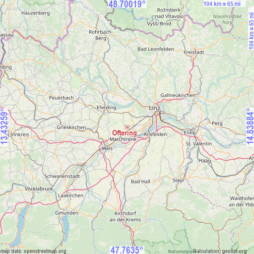
Oftering GPS coordinates[2]
48° 14' 2.364" North, 14° 8' 8.556" East
| Map corner | latitude | longitude |
|---|---|---|
| Upper-left | 48.70019°, | 13.43259° |
| Center: | 48.23399°, | 14.13571° |
| Lower-right: | 47.7635°, | 14.83884° |
| Map W x H: | 104.2×104.1 km | = 64.7×64.7mi |
| max Lat: | 48.98333° ⇑18.1% North |
| Oftering: | 48.23399° |
| min Lat: | ⇓81.9% South 46.48841° |
| min Long | Oftering | max Long |
| 9.57802° | 14.13571° | 17.1° |
| W 38.2%⇐ | ⇒61.8% E |
Elevation
Elevation of Oftering is 309 m = 1014 ft, and this is 196.5 m = 645 ft below average elevation for this country.
| Max E: |
2140 m = 7021 ft | 74.1% |
| Avg. | 505.5 m = 1658 ft | |
| Oftering | 309 m = 1014 ft | |
Min E: |
118 m = 387 ft | 25.9% |
See also: Austria elevation on elevation.city.
Geographical zone
Oftering is located in North temperate zone (between Tropic of Cancer and the Arctic Circle). Distance of this North polar circle is 2038.1 km =1266.4 mi to North.| Distance of | km | miles | from Oftering |
|---|---|---|---|
| North Pole | 4643.9 | 2885.6 | to North |
| Arctic Circle | 2038.1 | 1266.4 | to North |
| Tropic Cancer | 2757.2 | 1713.2 | to South |
| Equator | 5363.1 | 3332.5 | to South |


Nearby cities:
15 places around Oftering: (largest is in red/bold)
• Au an der Traun
6.2 km =3.9 mi,  196°
196°
• Hartheim
5.4 km =3.4 mi,  343°
343°
• Holzhausen
3.1 km =1.9 mi,  246°
246°
• Hörsching
3.2 km =2 mi,  105°
105°
• Marchtrenk
4.9 km =3 mi, 199°
• Mitterperwend
4.5 km =2.8 mi,  225°
225°
• Neubau
4.6 km =2.9 mi, 111°
• Oedt
6 km =3.7 mi, 112°
• Pasching
5.8 km =3.6 mi,  60°
60°
• Rutzing
4.9 km =3 mi,  131°
131°
• Sammersdorf
6.3 km =3.9 mi,  158°
158°
• Strassham
5.5 km =3.4 mi,  7°
7°
• Thening
3.4 km =2.1 mi,  45°
45°
• Unterhart
5.4 km =3.4 mi,  216°
216°
• Öhndorf
5 km =3.1 mi,  124°
124°
Sources, notices
• [Note1] Compared only with cities in Austria existing in our database
• [Src1] Map data: © OpenStreetMap contributors (CC-BY-SA)
• [Src2] Other city data from geonames.org with taken over terms of usage.
• [Src3] Geographical zone / Annual Mean Temperature by Robert A. Rohde @ Wikipedia
