Marchtrenk geodata
Marchtrenk (Upper Austria) is a seat of a third-order administrative division; located in Austria in Europe/Vienna (GMT+2) time zone. With population of 8,394 people, there are 106 cities with bigger population in this country. Compared to other cities in Austria, 78.8% of cities are located further ↓South; 62.4% of cities are located further →East and 75.3% of cities have higher elevation than Marchtrenk. Note1


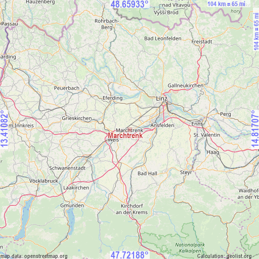
Marchtrenk GPS coordinates[2]
48° 11' 33.9" North, 14° 6' 50.184" East
| Map corner | latitude | longitude |
|---|---|---|
| Upper-left | 48.65933°, | 13.41082° |
| Center: | 48.19275°, | 14.11394° |
| Lower-right: | 47.72188°, | 14.81707° |
| Map W x H: | 104.2×104.2 km | = 64.7×64.7mi |
| max Lat: | 48.98333° ⇑21.2% North |
| Marchtrenk: | 48.19275° |
| min Lat: | ⇓78.8% South 46.48841° |
| min Long | Marchtrenk | max Long |
| 9.57802° | 14.11394° | 17.1° |
| W 37.6%⇐ | ⇒62.4% E |
Elevation
Elevation of Marchtrenk is 301 m = 988 ft, and this is 204.5 m = 671 ft below average elevation for this country.
| Max E: |
2140 m = 7021 ft | 75.3% |
| Avg. | 505.5 m = 1658 ft | |
| Marchtrenk | 301 m = 988 ft | |
Min E: |
118 m = 387 ft | 24.7% |
See also: Austria elevation on elevation.city.
Geographical zone
Marchtrenk is located in North temperate zone (between Tropic of Cancer and the Arctic Circle). Distance of this North polar circle is 2042.6 km =1269.2 mi to North.| Distance of | km | miles | from Marchtrenk |
|---|---|---|---|
| North Pole | 4648.5 | 2888.4 | to North |
| Arctic Circle | 2042.6 | 1269.2 | to North |
| Tropic Cancer | 2752.6 | 1710.4 | to South |
| Equator | 5358.5 | 3329.6 | to South |


Nearby cities:
15 places around Marchtrenk: (largest is in red/bold)
• Au an der Traun
1.4 km =0.9 mi,  184°
184°
• Bergern
2.8 km =1.7 mi, 183°
• Dickerldorf
4.6 km =2.9 mi,  247°
247°
• Haidl
5 km =3.1 mi,  243°
243°
• Holzhausen
3.6 km =2.2 mi,  339°
339°
• Mitterperwend
2.1 km =1.3 mi,  311°
311°
• Oberhart
4.9 km =3 mi,  257°
257°
• Oftering
4.9 km =3 mi,  19°
19°
• Pucking
5.5 km =3.4 mi,  94°
94°
• Rutzing
5.5 km =3.4 mi,  75°
75°
• Sammersdorf
4.1 km =2.5 mi,  108°
108°
• Schafwiesen
4.5 km =2.8 mi,  230°
230°
• Schleissheim
4.6 km =2.9 mi,  219°
219°
• Unterhart
1.7 km =1.1 mi,  279°
279°
• Weisskirchen an der Traun
3.5 km =2.2 mi,  167°
167°
Sources, notices
• [Note1] Compared only with cities in Austria existing in our database
• [Src1] Map data: © OpenStreetMap contributors (CC-BY-SA)
• [Src2] Other city data from geonames.org with taken over terms of usage.
• [Src3] Geographical zone / Annual Mean Temperature by Robert A. Rohde @ Wikipedia
