Oepping geodata
Oepping (Upper Austria) is a seat of a third-order administrative division; located in Austria in Europe/Vienna (GMT+2) time zone. With population of 299 people, there are 2741 cities with bigger population in this country. Compared to other cities in Austria, 96.8% of cities are located further ↓South; 66.1% of cities are located further →East and 73% of cities have lower elevation than Oepping. Note1
Administrative division(s):
- Level 1: Upper Austria
- Level 2: Politischer Bezirk Rohrbach
- Level 3: Oepping


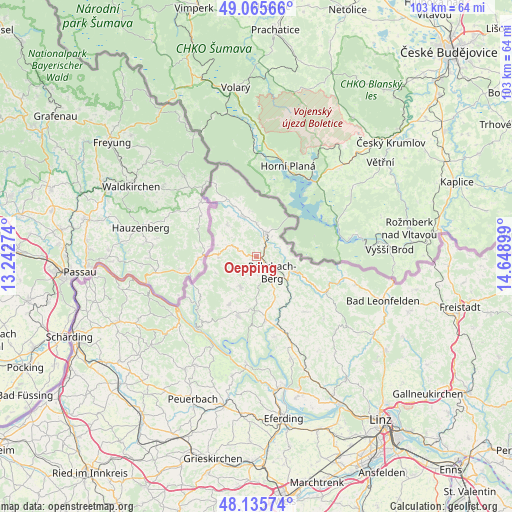
Oepping GPS coordinates[2]
48° 36' 10.224" North, 13° 56' 45.096" East
| Map corner | latitude | longitude |
|---|---|---|
| Upper-left | 49.06566°, | 13.24274° |
| Center: | 48.60284°, | 13.94586° |
| Lower-right: | 48.13574°, | 14.64899° |
| Map W x H: | 103.4×103.4 km | = 64.2×64.2mi |
| max Lat: | 48.98333° ⇑3.2% North |
| Oepping: | 48.60284° |
| min Lat: | ⇓96.8% South 46.48841° |
| min Long | Oepping | max Long |
| 9.57802° | 13.94586° | 17.1° |
| W 33.9%⇐ | ⇒66.1% E |
Elevation
Elevation of Oepping is 624 m = 2047 ft, and this is 118.5 m = 389 ft above average elevation for this country.
| Max E: |
2140 m = 7021 ft | 27% |
| Oepping | 624 m 2047 ft | |
| Avg. | 505.5 m = 1658 ft | |
Min E: |
118 m = 387 ft | 73% |
See also: Austria elevation on elevation.city.
Geographical zone
Oepping is located in North temperate zone (between Tropic of Cancer and the Arctic Circle). Distance of this North polar circle is 1997 km =1240.9 mi to North.| Distance of | km | miles | from Oepping |
|---|---|---|---|
| North Pole | 4602.9 | 2860.1 | to North |
| Arctic Circle | 1997 | 1240.9 | to North |
| Tropic Cancer | 2798.2 | 1738.7 | to South |
| Equator | 5404.1 | 3358 | to South |


Nearby cities:
15 places around Oepping: (largest is in red/bold)
• Aigen im Mühlkreis
5.1 km =3.2 mi,  21°
21°
• Arnreit
9.4 km =5.8 mi,  157°
157°
• Atzesberg
9 km =5.6 mi,  218°
218°
• Berg bei Rohrbach
4.3 km =2.7 mi,  129°
129°
• Haslach an der Mühl
7.5 km =4.7 mi,  113°
113°
• Julbach
8.8 km =5.5 mi,  317°
317°
• Klaffer am Hochficht
11.3 km =7 mi,  335°
335°
• Kollerschlag
7.7 km =4.8 mi,  271°
271°
• Lembach im Mühlkreis
12.5 km =7.8 mi,  197°
197°
• Nebelberg
7.9 km =4.9 mi,  291°
291°
• Peilstein im Mühlviertel
4.1 km =2.5 mi, 293°
• Putzleinsdorf
11 km =6.8 mi,  208°
208°
• Rohrbach in Oberösterreich
4.6 km =2.9 mi,  136°
136°
• Sarleinsbach
7.1 km =4.4 mi, 205°
• Ulrichsberg
8.4 km =5.2 mi, 342°
Sources, notices
• [Note1] Compared only with cities in Austria existing in our database
• [Src1] Map data: © OpenStreetMap contributors (CC-BY-SA)
• [Src2] Other city data from geonames.org with taken over terms of usage.
• [Src3] Geographical zone / Annual Mean Temperature by Robert A. Rohde @ Wikipedia
