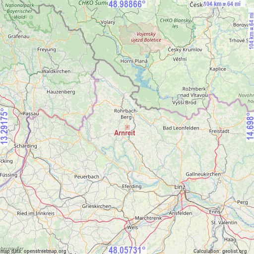
Arnreit geodata
Arnreit (Upper Austria) is a seat of a third-order administrative division; located in Austria in Europe/Vienna (GMT+2) time zone. With population of 141 people, there are 2902 cities with bigger population in this country. Compared to other cities in Austria, 94.9% of cities are located further ↓South; 65.1% of cities are located further →East and 71.3% of cities have lower elevation than Arnreit. Note1
Administrative division(s):
- Level 1: Upper Austria
- Level 2: Politischer Bezirk Rohrbach
- Level 3: Arnreit


Arnreit GPS coordinates[2]
48° 31' 30.468" North, 13° 59' 41.532" East
| Map corner | latitude | longitude |
|---|---|---|
| Upper-left | 48.98866°, | 13.29175° |
| Center: | 48.52513°, | 13.99487° |
| Lower-right: | 48.05731°, | 14.698° |
| Map W x H: | 103.6×103.6 km | = 64.4×64.4mi |
| max Lat: | 48.98333° ⇑5.1% North |
| Arnreit: | 48.52513° |
| min Lat: | ⇓94.9% South 46.48841° |
| min Long | Arnreit | max Long |
| 9.57802° | 13.99487° | 17.1° |
| W 34.9%⇐ | ⇒65.1% E |
Elevation
Elevation of Arnreit is 604 m = 1982 ft, and this is 98.5 m = 323 ft above average elevation for this country.
| Max E: |
2140 m = 7021 ft | 28.7% |
| Arnreit | 604 m 1982 ft | |
| Avg. | 505.5 m = 1658 ft | |
Min E: |
118 m = 387 ft | 71.3% |
See also: Austria elevation on elevation.city.
Geographical zone
Arnreit is located in North temperate zone (between Tropic of Cancer and the Arctic Circle). Distance of this North polar circle is 2005.7 km =1246.3 mi to North.| Distance of | km | miles | from Arnreit |
|---|---|---|---|
| North Pole | 4611.6 | 2865.5 | to North |
| Arctic Circle | 2005.7 | 1246.3 | to North |
| Tropic Cancer | 2789.6 | 1733.4 | to South |
| Equator | 5395.5 | 3352.6 | to South |


Nearby cities:
15 places around Arnreit: (largest is in red/bold)
• Afiesl
11.7 km =7.3 mi,  56°
56°
• Altenfelden
4.8 km =3 mi,  202°
202°
• Atzesberg
9.4 km =5.8 mi,  279°
279°
• Berg bei Rohrbach
5.9 km =3.7 mi,  357°
357°
• Haslach an der Mühl
6.5 km =4 mi,  30°
30°
• Kirchberg ob der Donau
9.9 km =6.2 mi,  205°
205°
• Lembach im Mühlkreis
8.1 km =5 mi,  245°
245°
• Neufelden
4.6 km =2.9 mi,  178°
178°
• Niederwaldkirchen
10.7 km =6.6 mi,  141°
141°
• Oepping
9.4 km =5.8 mi,  337°
337°
• Putzleinsdorf
9 km =5.6 mi,  263°
263°
• Rohrbach in Oberösterreich
5.3 km =3.3 mi,  354°
354°
• Sankt Johann am Wimberg
10.8 km =6.7 mi,  112°
112°
• Sankt Peter am Wimberg
6.6 km =4.1 mi, 112°
• Sarleinsbach
7 km =4.3 mi,  288°
288°
Sources, notices
• [Note1] Compared only with cities in Austria existing in our database
• [Src1] Map data: © OpenStreetMap contributors (CC-BY-SA)
• [Src2] Other city data from geonames.org with taken over terms of usage.
• [Src3] Geographical zone / Annual Mean Temperature by Robert A. Rohde @ Wikipedia
