Oberpremstätten geodata
Oberpremstätten (Styria) is a populated place; located in Austria in Europe/Vienna (GMT+2) time zone. With population of 1,243 people, there are 1012 cities with bigger population in this country. Compared to other cities in Austria, 85.3% of cities are located further ↑North; 63% of cities are located further ←West and 69.4% of cities have higher elevation than Oberpremstätten. Note1
Administrative division(s):
- Level 1: Styria
- Level 2: Politischer Bezirk Graz-Umgebung
- Level 3: Unterpremstätten-Zettling


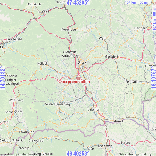
Oberpremstätten GPS coordinates[2]
46° 58' 27.984" North, 15° 24' 15.984" East
| Map corner | latitude | longitude |
|---|---|---|
| Upper-left | 47.45205°, | 14.70132° |
| Center: | 46.97444°, | 15.40444° |
| Lower-right: | 46.49253°, | 16.10757° |
| Map W x H: | 106.7×106.7 km | = 66.3×66.3mi |
| max Lat: | 48.98333° ⇑85.3% North |
| Oberpremstätten: | 46.97444° |
| min Lat: | ⇓14.7% South 46.48841° |
| min Long | Oberpremstätte | max Long |
| 9.57802° | 15.40444° | 17.1° |
| W 63%⇐ | ⇒37% E |
Elevation
Elevation of Oberpremstätten is 332 m = 1089 ft, and this is 173.5 m = 569 ft below average elevation for this country.
| Max E: |
2140 m = 7021 ft | 69.4% |
| Avg. | 505.5 m = 1658 ft | |
| Oberpremstätten | 332 m = 1089 ft | |
Min E: |
118 m = 387 ft | 30.6% |
See also: Austria elevation on elevation.city.
Geographical zone
Oberpremstätten is located in North temperate zone (between Tropic of Cancer and the Arctic Circle). Distance of this North polar circle is 2178.1 km =1353.4 mi to North.| Distance of | km | miles | from Oberpremstätten |
|---|---|---|---|
| North Pole | 4784 | 2972.6 | to North |
| Arctic Circle | 2178.1 | 1353.4 | to North |
| Tropic Cancer | 2617.1 | 1626.2 | to South |
| Equator | 5223.1 | 3245.5 | to South |


Nearby cities:
15 places around Oberpremstätten: (largest is in red/bold)
• Abtissendorf
4.6 km =2.9 mi,  58°
58°
• Bierbaum
1.5 km =0.9 mi,  136°
136°
• Dobldorf
3.9 km =2.4 mi,  226°
226°
• Hautzendorf
1 km =0.6 mi,  341°
341°
• Laa
2.9 km =1.8 mi,  161°
161°
• Lebern
4.5 km =2.8 mi,  50°
50°
• Lieboch
5.1 km =3.2 mi,  269°
269°
• Muttendorf
5.4 km =3.4 mi,  212°
212°
• Pirka
3.3 km =2.1 mi,  330°
330°
• Seiersberg
2.9 km =1.8 mi,  353°
353°
• Spatenhof
3.5 km =2.2 mi,  248°
248°
• Unterpremstätten
1.1 km =0.7 mi,  181°
181°
• Wagnitz
4.8 km =3 mi,  78°
78°
• Windorf
2 km =1.2 mi, 351°
• Zettling
3.3 km =2.1 mi, 137°
Sources, notices
• [Note1] Compared only with cities in Austria existing in our database
• [Src1] Map data: © OpenStreetMap contributors (CC-BY-SA)
• [Src2] Other city data from geonames.org with taken over terms of usage.
• [Src3] Geographical zone / Annual Mean Temperature by Robert A. Rohde @ Wikipedia
