Muttendorf geodata
Muttendorf (Styria) is a populated place; located in Austria in Europe/Vienna (GMT+2) time zone. With population of 624 people, there are 2052 cities with bigger population in this country. Compared to other cities in Austria, 87.1% of cities are located further ↑North; 61.9% of cities are located further ←West and 71.7% of cities have higher elevation than Muttendorf. Note1
Administrative division(s):
- Level 1: Styria
- Level 2: Politischer Bezirk Graz-Umgebung
- Level 3: Dobl-Zwaring


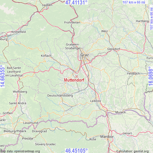
Muttendorf GPS coordinates[2]
46° 55' 59.988" North, 15° 22' 0.012" East
| Map corner | latitude | longitude |
|---|---|---|
| Upper-left | 47.41131°, | 14.66355° |
| Center: | 46.93333°, | 15.36667° |
| Lower-right: | 46.45105°, | 16.0698° |
| Map W x H: | 106.8×106.8 km | = 66.4×66.4mi |
| max Lat: | 48.98333° ⇑87.1% North |
| Muttendorf: | 46.93333° |
| min Lat: | ⇓12.9% South 46.48841° |
| min Long | Muttendorf | max Long |
| 9.57802° | 15.36667° | 17.1° |
| W 61.9%⇐ | ⇒38.1% E |
Elevation
Elevation of Muttendorf is 320 m = 1050 ft, and this is 185.5 m = 609 ft below average elevation for this country.
| Max E: |
2140 m = 7021 ft | 71.7% |
| Avg. | 505.5 m = 1658 ft | |
| Muttendorf | 320 m = 1050 ft | |
Min E: |
118 m = 387 ft | 28.3% |
See also: Austria elevation on elevation.city.
Geographical zone
Muttendorf is located in North temperate zone (between Tropic of Cancer and the Arctic Circle). Distance of this North polar circle is 2182.7 km =1356.3 mi to North.| Distance of | km | miles | from Muttendorf |
|---|---|---|---|
| North Pole | 4788.6 | 2975.5 | to North |
| Arctic Circle | 2182.7 | 1356.3 | to North |
| Tropic Cancer | 2612.6 | 1623.4 | to South |
| Equator | 5218.5 | 3242.6 | to South |


Nearby cities:
15 places around Muttendorf: (largest is in red/bold)
• Bierbaum
5.2 km =3.2 mi,  48°
48°
• Blumegg
3.3 km =2.1 mi,  267°
267°
• Dobldorf
1.9 km =1.2 mi,  0°
0°
• Hautzendorf
6.1 km =3.8 mi,  24°
24°
• Laa
4.2 km =2.6 mi,  63°
63°
• Lannach
2.6 km =1.6 mi,  302°
302°
• Lieboch
5.1 km =3.2 mi,  334°
334°
• Oberpremstätten
5.4 km =3.4 mi,  32°
32°
• Sankt Josef (Weststeiermark)
3.5 km =2.2 mi,  220°
220°
• Schadendorf
6.7 km =4.2 mi, 327°
• Spatenhof
3.3 km =2.1 mi,  352°
352°
• Unterpremstätten
4.5 km =2.8 mi,  39°
39°
• Windorf
7.1 km =4.4 mi, 21°
• Wundschuh
6.5 km =4 mi,  96°
96°
• Zettling
5.5 km =3.4 mi,  67°
67°
Sources, notices
• [Note1] Compared only with cities in Austria existing in our database
• [Src1] Map data: © OpenStreetMap contributors (CC-BY-SA)
• [Src2] Other city data from geonames.org with taken over terms of usage.
• [Src3] Geographical zone / Annual Mean Temperature by Robert A. Rohde @ Wikipedia
