Oberhaag geodata
Oberhaag (Styria) is a seat of a third-order administrative division; located in Austria in Europe/Vienna (GMT+2) time zone. With population of 716 people, there are 1815 cities with bigger population in this country. Compared to other cities in Austria, 95.7% of cities are located further ↑North; 61.1% of cities are located further ←West and 70.8% of cities have higher elevation than Oberhaag. Note1


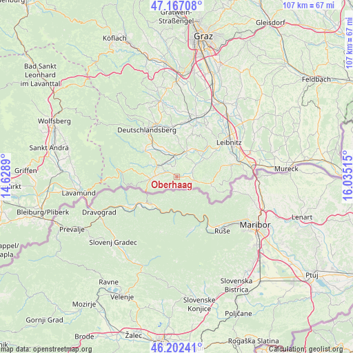
Oberhaag GPS coordinates[2]
46° 41' 12.84" North, 15° 19' 55.272" East
| Map corner | latitude | longitude |
|---|---|---|
| Upper-left | 47.16708°, | 14.6289° |
| Center: | 46.6869°, | 15.33202° |
| Lower-right: | 46.20241°, | 16.03515° |
| Map W x H: | 107.3×107.3 km | = 66.7×66.7mi |
| max Lat: | 48.98333° ⇑95.7% North |
| Oberhaag: | 46.6869° |
| min Lat: | ⇓4.3% South 46.48841° |
| min Long | Oberhaag | max Long |
| 9.57802° | 15.33202° | 17.1° |
| W 61.1%⇐ | ⇒38.9% E |
Elevation
Elevation of Oberhaag is 324 m = 1063 ft, and this is 181.5 m = 595 ft below average elevation for this country.
| Max E: |
2140 m = 7021 ft | 70.8% |
| Avg. | 505.5 m = 1658 ft | |
| Oberhaag | 324 m = 1063 ft | |
Min E: |
118 m = 387 ft | 29.2% |
See also: Austria elevation on elevation.city.
Geographical zone
Oberhaag is located in North temperate zone (between Tropic of Cancer and the Arctic Circle). Distance of this North polar circle is 2210.1 km =1373.3 mi to North.| Distance of | km | miles | from Oberhaag |
|---|---|---|---|
| North Pole | 4816 | 2992.5 | to North |
| Arctic Circle | 2210.1 | 1373.3 | to North |
| Tropic Cancer | 2585.2 | 1606.4 | to South |
| Equator | 5191.1 | 3225.6 | to South |


Nearby cities:
15 places around Oberhaag: (largest is in red/bold)
• Aibl
8.1 km =5 mi,  265°
265°
• Altenmarkt bei Wies
7.1 km =4.4 mi,  297°
297°
• Arnfels
5.5 km =3.4 mi,  102°
102°
• Brunn
5.3 km =3.3 mi,  332°
332°
• Eibiswald
6.5 km =4 mi, 269°
• Eichberg-Trautenburg
9.3 km =5.8 mi,  86°
86°
• Gleinstätten
8 km =5 mi,  21°
21°
• Hörmsdorf
5.3 km =3.3 mi,  277°
277°
• Mitterlimberg
9.1 km =5.7 mi, 304°
• Pistorf
9.3 km =5.8 mi, 16°
• Pitschgau
5.2 km =3.2 mi,  286°
286°
• Sankt Johann im Saggautal
5.7 km =3.5 mi,  70°
70°
• Sankt Martin im Sulmtal
8.1 km =5 mi,  340°
340°
• Untergreith
3.6 km =2.2 mi, 22°
• Wies
5.9 km =3.7 mi,  309°
309°
Sources, notices
• [Note1] Compared only with cities in Austria existing in our database
• [Src1] Map data: © OpenStreetMap contributors (CC-BY-SA)
• [Src2] Other city data from geonames.org with taken over terms of usage.
• [Src3] Geographical zone / Annual Mean Temperature by Robert A. Rohde @ Wikipedia
