Pistorf geodata
Pistorf (Styria) is a seat of a third-order administrative division; located in Austria in Europe/Vienna (GMT+2) time zone. With population of 611 people, there are 2099 cities with bigger population in this country. Compared to other cities in Austria, 93% of cities are located further ↑North; 61.9% of cities are located further ←West and 71.5% of cities have higher elevation than Pistorf. Note1
Administrative division(s):
- Level 1: Styria
- Level 2: Politischer Bezirk Leibnitz
- Level 3: Gleinstätten


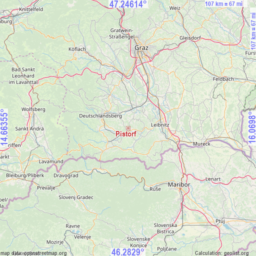
Pistorf GPS coordinates[2]
46° 46' 0.012" North, 15° 22' 0.012" East
| Map corner | latitude | longitude |
|---|---|---|
| Upper-left | 47.24614°, | 14.66355° |
| Center: | 46.76667°, | 15.36667° |
| Lower-right: | 46.2829°, | 16.0698° |
| Map W x H: | 107.1×107.1 km | = 66.5×66.5mi |
| max Lat: | 48.98333° ⇑93% North |
| Pistorf: | 46.76667° |
| min Lat: | ⇓7% South 46.48841° |
| min Long | Pistorf | max Long |
| 9.57802° | 15.36667° | 17.1° |
| W 61.9%⇐ | ⇒38.1% E |
Elevation
Elevation of Pistorf is 321 m = 1053 ft, and this is 184.5 m = 605 ft below average elevation for this country.
| Max E: |
2140 m = 7021 ft | 71.5% |
| Avg. | 505.5 m = 1658 ft | |
| Pistorf | 321 m = 1053 ft | |
Min E: |
118 m = 387 ft | 28.5% |
See also: Austria elevation on elevation.city.
Geographical zone
Pistorf is located in North temperate zone (between Tropic of Cancer and the Arctic Circle). Distance of this North polar circle is 2201.2 km =1367.8 mi to North.| Distance of | km | miles | from Pistorf |
|---|---|---|---|
| North Pole | 4807.1 | 2987 | to North |
| Arctic Circle | 2201.2 | 1367.8 | to North |
| Tropic Cancer | 2594 | 1611.8 | to South |
| Equator | 5200 | 3231.1 | to South |


Nearby cities:
15 places around Pistorf: (largest is in red/bold)
• Brunn
6.6 km =4.1 mi,  230°
230°
• Gleinstätten
1.5 km =0.9 mi,  170°
170°
• Groß Sankt Florian
7.4 km =4.6 mi,  330°
330°
• Großklein
6.8 km =4.2 mi,  119°
119°
• Heimschuh
9.7 km =6 mi,  94°
94°
• Kitzeck im Sausal
6.8 km =4.2 mi,  76°
76°
• Oberhaag
9.3 km =5.8 mi,  196°
196°
• Sankt Johann im Saggautal
7.5 km =4.7 mi,  158°
158°
• Sankt Martin im Sulmtal
5.4 km =3.4 mi,  257°
257°
• Sankt Nikolai im Sausal
8.9 km =5.5 mi,  46°
46°
• Sankt Peter im Sulmtal
9.1 km =5.7 mi, 258°
• Unterbergla
6 km =3.7 mi,  319°
319°
• Untergreith
5.7 km =3.5 mi,  192°
192°
• Wettmannstätten
7.3 km =4.5 mi,  12°
12°
• Wies
8.9 km =5.5 mi, 234°
Sources, notices
• [Note1] Compared only with cities in Austria existing in our database
• [Src1] Map data: © OpenStreetMap contributors (CC-BY-SA)
• [Src2] Other city data from geonames.org with taken over terms of usage.
• [Src3] Geographical zone / Annual Mean Temperature by Robert A. Rohde @ Wikipedia
