Niederalm geodata
Niederalm (Salzburg) is a populated place; located in Austria in Europe/Vienna (GMT+2) time zone. With population of 1,575 people, there are 794 cities with bigger population in this country. Compared to other cities in Austria, 54.8% of cities are located further ↓South; 82.1% of cities are located further →East and 53.4% of cities have higher elevation than Niederalm. Note1
Administrative division(s):
- Level 1: Salzburg
- Level 2: Politischer Bezirk Salzburg-Umgebung
- Level 3: Anif


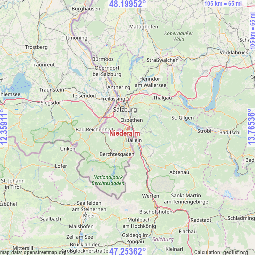
Niederalm GPS coordinates[2]
47° 43' 43.392" North, 13° 3' 44.028" East
| Map corner | latitude | longitude |
|---|---|---|
| Upper-left | 48.19952°, | 12.35911° |
| Center: | 47.72872°, | 13.06223° |
| Lower-right: | 47.25362°, | 13.76536° |
| Map W x H: | 105.2×105.2 km | = 65.4×65.4mi |
| max Lat: | 48.98333° ⇑45.2% North |
| Niederalm: | 47.72872° |
| min Lat: | ⇓54.8% South 46.48841° |
| min Long | Niederalm | max Long |
| 9.57802° | 13.06223° | 17.1° |
| W 17.9%⇐ | ⇒82.1% E |
Elevation
Elevation of Niederalm is 431 m = 1414 ft, and this is 74.5 m = 244 ft below average elevation for this country.
| Max E: |
2140 m = 7021 ft | 53.4% |
| Avg. | 505.5 m = 1658 ft | |
| Niederalm | 431 m = 1414 ft | |
Min E: |
118 m = 387 ft | 46.6% |
See also: Austria elevation on elevation.city.
Geographical zone
Niederalm is located in North temperate zone (between Tropic of Cancer and the Arctic Circle). Distance of this North polar circle is 2094.2 km =1301.3 mi to North.| Distance of | km | miles | from Niederalm |
|---|---|---|---|
| North Pole | 4700.1 | 2920.5 | to North |
| Arctic Circle | 2094.2 | 1301.3 | to North |
| Tropic Cancer | 2701 | 1678.3 | to South |
| Equator | 5306.9 | 3297.6 | to South |


Nearby cities:
15 places around Niederalm: (largest is in red/bold)
• Adnet
6.2 km =3.9 mi,  123°
123°
• Anif
2.4 km =1.5 mi,  7°
7°
• Au
3.2 km =2 mi,  174°
174°
• Burgfried
6.6 km =4.1 mi,  145°
145°
• Elsbethen
4.2 km =2.6 mi,  19°
19°
• Glanegg
5.2 km =3.2 mi,  296°
296°
• Glasenbach
4.5 km =2.8 mi, 20°
• Grödig
2.1 km =1.3 mi, 299°
• Hallein
5.8 km =3.6 mi, 150°
• Neu-Anif
1.1 km =0.7 mi,  319°
319°
• Neualm
4.4 km =2.7 mi, 154°
• Oberalm
4.3 km =2.7 mi,  138°
138°
• Puch bei Hallein
2.7 km =1.7 mi, 122°
• Sankt Leonhard
1.3 km =0.8 mi,  255°
255°
• Taxach
0.8 km =0.5 mi,  112°
112°
Sources, notices
• [Note1] Compared only with cities in Austria existing in our database
• [Src1] Map data: © OpenStreetMap contributors (CC-BY-SA)
• [Src2] Other city data from geonames.org with taken over terms of usage.
• [Src3] Geographical zone / Annual Mean Temperature by Robert A. Rohde @ Wikipedia
