Neu-Anif geodata
Neu-Anif (Salzburg) is a populated place; located in Austria in Europe/Vienna (GMT+2) time zone. With population of 806 people, there are 1602 cities with bigger population in this country. Compared to other cities in Austria, 55% of cities are located further ↓South; 82.3% of cities are located further →East and 53.6% of cities have higher elevation than Neu-Anif. Note1
Administrative division(s):
- Level 1: Salzburg
- Level 2: Politischer Bezirk Salzburg-Umgebung
- Level 3: Anif


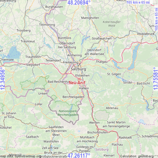
Neu-Anif GPS coordinates[2]
47° 44' 10.32" North, 13° 3' 9.648" East
| Map corner | latitude | longitude |
|---|---|---|
| Upper-left | 48.20694°, | 12.34956° |
| Center: | 47.7362°, | 13.05268° |
| Lower-right: | 47.26117°, | 13.75581° |
| Map W x H: | 105.2×105.2 km | = 65.4×65.4mi |
| max Lat: | 48.98333° ⇑45% North |
| Neu-Anif: | 47.7362° |
| min Lat: | ⇓55% South 46.48841° |
| min Long | Neu-Anif | max Long |
| 9.57802° | 13.05268° | 17.1° |
| W 17.7%⇐ | ⇒82.3% E |
Elevation
Elevation of Neu-Anif is 430 m = 1411 ft, and this is 75.5 m = 248 ft below average elevation for this country.
| Max E: |
2140 m = 7021 ft | 53.6% |
| Avg. | 505.5 m = 1658 ft | |
| Neu-Anif | 430 m = 1411 ft | |
Min E: |
118 m = 387 ft | 46.4% |
See also: Austria elevation on elevation.city.
Geographical zone
Neu-Anif is located in North temperate zone (between Tropic of Cancer and the Arctic Circle). Distance of this North polar circle is 2093.4 km =1300.8 mi to North.| Distance of | km | miles | from Neu-Anif |
|---|---|---|---|
| North Pole | 4699.3 | 2920 | to North |
| Arctic Circle | 2093.4 | 1300.8 | to North |
| Tropic Cancer | 2701.8 | 1678.8 | to South |
| Equator | 5307.8 | 3298.1 | to South |


Nearby cities:
15 places around Neu-Anif: (largest is in red/bold)
• Adnet
7.3 km =4.5 mi,  126°
126°
• Anif
1.9 km =1.2 mi,  34°
34°
• Au
4.2 km =2.6 mi,  165°
165°
• Elsbethen
3.8 km =2.4 mi, 33°
• Glanegg
4.2 km =2.6 mi,  291°
291°
• Glasenbach
4.1 km =2.5 mi, 34°
• Grödig
1.2 km =0.7 mi,  281°
281°
• Hallein
6.9 km =4.3 mi,  148°
148°
• Neualm
5.4 km =3.4 mi, 151°
• Niederalm
1.1 km =0.7 mi,  139°
139°
• Oberalm
5.4 km =3.4 mi, 138°
• Puch bei Hallein
3.8 km =2.4 mi, 127°
• Salzburg
7.1 km =4.4 mi,  354°
354°
• Sankt Leonhard
1.3 km =0.8 mi,  204°
204°
• Taxach
1.8 km =1.1 mi, 128°
Sources, notices
• [Note1] Compared only with cities in Austria existing in our database
• [Src1] Map data: © OpenStreetMap contributors (CC-BY-SA)
• [Src2] Other city data from geonames.org with taken over terms of usage.
• [Src3] Geographical zone / Annual Mean Temperature by Robert A. Rohde @ Wikipedia
