Grödig geodata
Grödig (Salzburg) is a seat of a third-order administrative division; located in Austria in Europe/Vienna (GMT+2) time zone. With population of 3,751 people, there are 286 cities with bigger population in this country. Compared to other cities in Austria, 55.1% of cities are located further ↓South; 82.5% of cities are located further →East and 50.5% of cities have higher elevation than Grödig. Note1
Administrative division(s):
- Level 1: Salzburg
- Level 2: Politischer Bezirk Salzburg-Umgebung
- Level 3: Grödig


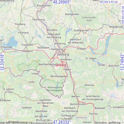
Grödig GPS coordinates[2]
47° 44' 17.988" North, 13° 2' 14.28" East
| Map corner | latitude | longitude |
|---|---|---|
| Upper-left | 48.20905°, | 12.33418° |
| Center: | 47.73833°, | 13.0373° |
| Lower-right: | 47.26332°, | 13.74043° |
| Map W x H: | 105.2×105.2 km | = 65.4×65.4mi |
| max Lat: | 48.98333° ⇑44.9% North |
| Grödig: | 47.73833° |
| min Lat: | ⇓55.1% South 46.48841° |
| min Long | Grödig | max Long |
| 9.57802° | 13.0373° | 17.1° |
| W 17.5%⇐ | ⇒82.5% E |
Elevation
Elevation of Grödig is 448 m = 1470 ft, and this is 57.5 m = 189 ft below average elevation for this country.
| Max E: |
2140 m = 7021 ft | 50.5% |
| Avg. | 505.5 m = 1658 ft | |
| Grödig | 448 m = 1470 ft | |
Min E: |
118 m = 387 ft | 49.5% |
See also: Austria elevation on elevation.city.
Geographical zone
Grödig is located in North temperate zone (between Tropic of Cancer and the Arctic Circle). Distance of this North polar circle is 2093.2 km =1300.7 mi to North.| Distance of | km | miles | from Grödig |
|---|---|---|---|
| North Pole | 4699.1 | 2919.9 | to North |
| Arctic Circle | 2093.2 | 1300.7 | to North |
| Tropic Cancer | 2702.1 | 1679 | to South |
| Equator | 5308 | 3298.2 | to South |


Nearby cities:
15 places around Grödig: (largest is in red/bold)
• Anif
2.6 km =1.6 mi,  59°
59°
• Au
4.8 km =3 mi,  152°
152°
• Elsbethen
4.4 km =2.7 mi,  48°
48°
• Glanegg
3.1 km =1.9 mi,  294°
294°
• Glasenbach
4.7 km =2.9 mi, 47°
• Gois
6.1 km =3.8 mi,  300°
300°
• Neu-Anif
1.2 km =0.7 mi,  101°
101°
• Neualm
6.3 km =3.9 mi,  143°
143°
• Niederalm
2.1 km =1.3 mi,  119°
119°
• Oberalm
6.3 km =3.9 mi,  132°
132°
• Puch bei Hallein
4.9 km =3 mi, 121°
• Salzburg
6.8 km =4.2 mi,  4°
4°
• Sankt Leonhard
1.5 km =0.9 mi,  155°
155°
• Taxach
2.9 km =1.8 mi, 117°
• Viehhausen
6.4 km =4 mi,  321°
321°
Sources, notices
• [Note1] Compared only with cities in Austria existing in our database
• [Src1] Map data: © OpenStreetMap contributors (CC-BY-SA)
• [Src2] Other city data from geonames.org with taken over terms of usage.
• [Src3] Geographical zone / Annual Mean Temperature by Robert A. Rohde @ Wikipedia
