Natternbach geodata
Natternbach (Upper Austria) is a seat of a third-order administrative division; located in Austria in Europe/Vienna (GMT+2) time zone. With population of 1,027 people, there are 1249 cities with bigger population in this country. Compared to other cities in Austria, 90.6% of cities are located further ↓South; 70.4% of cities are located further →East and 53% of cities have higher elevation than Natternbach. Note1
Administrative division(s):
- Level 1: Upper Austria
- Level 2: Politischer Bezirk Grieskirchen
- Level 3: Natternbach


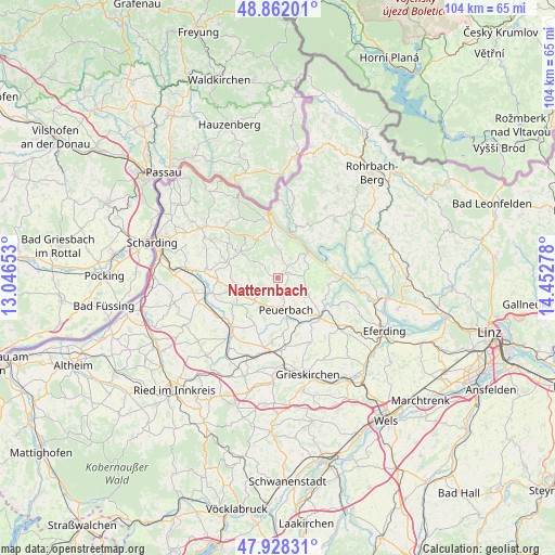
Natternbach GPS coordinates[2]
48° 23' 50.28" North, 13° 44' 58.74" East
| Map corner | latitude | longitude |
|---|---|---|
| Upper-left | 48.86201°, | 13.04653° |
| Center: | 48.3973°, | 13.74965° |
| Lower-right: | 47.92831°, | 14.45278° |
| Map W x H: | 103.8×103.8 km | = 64.5×64.5mi |
| max Lat: | 48.98333° ⇑9.4% North |
| Natternbach: | 48.3973° |
| min Lat: | ⇓90.6% South 46.48841° |
| min Long | Natternbach | max Long |
| 9.57802° | 13.74965° | 17.1° |
| W 29.6%⇐ | ⇒70.4% E |
Elevation
Elevation of Natternbach is 435 m = 1427 ft, and this is 70.5 m = 231 ft below average elevation for this country.
| Max E: |
2140 m = 7021 ft | 53% |
| Avg. | 505.5 m = 1658 ft | |
| Natternbach | 435 m = 1427 ft | |
Min E: |
118 m = 387 ft | 47% |
See also: Austria elevation on elevation.city.
Geographical zone
Natternbach is located in North temperate zone (between Tropic of Cancer and the Arctic Circle). Distance of this North polar circle is 2019.9 km =1255.1 mi to North.| Distance of | km | miles | from Natternbach |
|---|---|---|---|
| North Pole | 4625.8 | 2874.3 | to North |
| Arctic Circle | 2019.9 | 1255.1 | to North |
| Tropic Cancer | 2775.4 | 1724.6 | to South |
| Equator | 5381.3 | 3343.8 | to South |


Nearby cities:
15 places around Natternbach: (largest is in red/bold)
• Andorf
13.3 km =8.3 mi,  257°
257°
• Enzenkirchen
7.6 km =4.7 mi, 262°
• Hofkirchen im Mühlkreis
10.5 km =6.5 mi,  24°
24°
• Kallham
12.8 km =8 mi,  192°
192°
• Kopfing im Innkreis
8.2 km =5.1 mi,  305°
305°
• Neukirchen am Walde
2.5 km =1.6 mi,  68°
68°
• Peuerbach
6 km =3.7 mi,  164°
164°
• Pötting
12.8 km =8 mi,  173°
173°
• Raab
9.1 km =5.7 mi,  236°
236°
• Sankt Aegidi
9.2 km =5.7 mi,  354°
354°
• Sankt Agatha
9.5 km =5.9 mi,  97°
97°
• Sigharting
11.2 km =7 mi,  269°
269°
• Waizenkirchen
10.9 km =6.8 mi,  133°
133°
• Waldkirchen am Wesen
7.2 km =4.5 mi,  47°
47°
• Zell an der Pram
12.7 km =7.9 mi,  224°
224°
Sources, notices
• [Note1] Compared only with cities in Austria existing in our database
• [Src1] Map data: © OpenStreetMap contributors (CC-BY-SA)
• [Src2] Other city data from geonames.org with taken over terms of usage.
• [Src3] Geographical zone / Annual Mean Temperature by Robert A. Rohde @ Wikipedia
