Raab geodata
Raab (Upper Austria) is a populated place; located in Austria in Europe/Vienna (GMT+2) time zone. With population of 1,429 people, there are 879 cities with bigger population in this country. Compared to other cities in Austria, 88.6% of cities are located further ↓South; 72.5% of cities are located further →East and 60.5% of cities have higher elevation than Raab. Note1
Administrative division(s):
- Level 1: Upper Austria
- Level 2: Politischer Bezirk Schärding
- Level 3: Raab


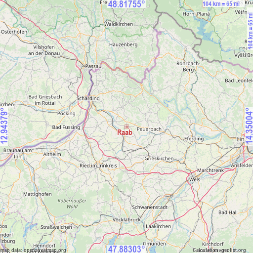
Raab GPS coordinates[2]
48° 21' 8.748" North, 13° 38' 48.876" East
| Map corner | latitude | longitude |
|---|---|---|
| Upper-left | 48.81755°, | 12.94379° |
| Center: | 48.35243°, | 13.64691° |
| Lower-right: | 47.88303°, | 14.35004° |
| Map W x H: | 103.9×103.9 km | = 64.6×64.6mi |
| max Lat: | 48.98333° ⇑11.4% North |
| Raab: | 48.35243° |
| min Lat: | ⇓88.6% South 46.48841° |
| min Long | Raab | max Long |
| 9.57802° | 13.64691° | 17.1° |
| W 27.5%⇐ | ⇒72.5% E |
Elevation
Elevation of Raab is 380 m = 1247 ft, and this is 125.5 m = 412 ft below average elevation for this country.
| Max E: |
2140 m = 7021 ft | 60.5% |
| Avg. | 505.5 m = 1658 ft | |
| Raab | 380 m = 1247 ft | |
Min E: |
118 m = 387 ft | 39.5% |
See also: Austria elevation on elevation.city.
Geographical zone
Raab is located in North temperate zone (between Tropic of Cancer and the Arctic Circle). Distance of this North polar circle is 2024.9 km =1258.2 mi to North.| Distance of | km | miles | from Raab |
|---|---|---|---|
| North Pole | 4630.8 | 2877.4 | to North |
| Arctic Circle | 2024.9 | 1258.2 | to North |
| Tropic Cancer | 2770.4 | 1721.4 | to South |
| Equator | 5376.3 | 3340.7 | to South |


Nearby cities:
15 places around Raab: (largest is in red/bold)
• Andorf
5.8 km =3.6 mi,  291°
291°
• Enzenkirchen
4 km =2.5 mi,  1°
1°
• Kallham
8.9 km =5.5 mi,  147°
147°
• Kopfing im Innkreis
9.8 km =6.1 mi, 4°
• Natternbach
9.1 km =5.7 mi,  56°
56°
• Neukirchen am Walde
11.6 km =7.2 mi, 59°
• Neumarkt im Hausruckkreis
10.7 km =6.6 mi, 145°
• Peuerbach
9.3 km =5.8 mi,  94°
94°
• Pram
13.4 km =8.3 mi,  193°
193°
• Pötting
11.9 km =7.4 mi,  130°
130°
• Sigharting
6.1 km =3.8 mi,  323°
323°
• Taiskirchen im Innkreis
11.2 km =7 mi,  209°
209°
• Taufkirchen an der Pram
10.3 km =6.4 mi,  309°
309°
• Wendling
13.5 km =8.4 mi,  173°
173°
• Zell an der Pram
4.2 km =2.6 mi,  197°
197°
Sources, notices
• [Note1] Compared only with cities in Austria existing in our database
• [Src1] Map data: © OpenStreetMap contributors (CC-BY-SA)
• [Src2] Other city data from geonames.org with taken over terms of usage.
• [Src3] Geographical zone / Annual Mean Temperature by Robert A. Rohde @ Wikipedia
