Mühlgraben geodata
Mühlgraben (Tyrol) is a populated place; located in Austria in Europe/Vienna (GMT+2) time zone. With population of 795 people, there are 1624 cities with bigger population in this country. Compared to other cities in Austria, 52.4% of cities are located further ↓South; 87.6% of cities are located further →East and 52.4% of cities have lower elevation than Mühlgraben. Note1


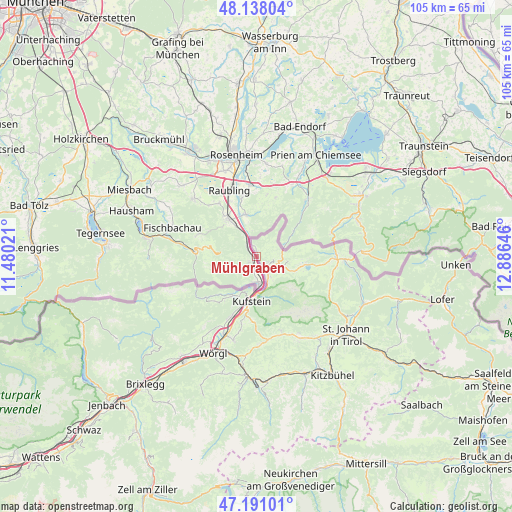
Mühlgraben GPS coordinates[2]
47° 40' 0.012" North, 12° 10' 59.988" East
| Map corner | latitude | longitude |
|---|---|---|
| Upper-left | 48.13804°, | 11.48021° |
| Center: | 47.66667°, | 12.18333° |
| Lower-right: | 47.19101°, | 12.88646° |
| Map W x H: | 105.3×105.3 km | = 65.4×65.4mi |
| max Lat: | 48.98333° ⇑47.6% North |
| Mühlgraben: | 47.66667° |
| min Lat: | ⇓52.4% South 46.48841° |
| min Long | Mühlgraben | max Long |
| 9.57802° | 12.18333° | 17.1° |
| W 12.4%⇐ | ⇒87.6% E |
Elevation
Elevation of Mühlgraben is 468 m = 1535 ft, and this is 37.5 m = 123 ft below average elevation for this country.
| Max E: |
2140 m = 7021 ft | 47.6% |
| Avg. | 505.5 m = 1658 ft | |
| Mühlgraben | 468 m = 1535 ft | |
Min E: |
118 m = 387 ft | 52.4% |
See also: Austria elevation on elevation.city.
Geographical zone
Mühlgraben is located in North temperate zone (between Tropic of Cancer and the Arctic Circle). Distance of this North polar circle is 2101.1 km =1305.6 mi to North.| Distance of | km | miles | from Mühlgraben |
|---|---|---|---|
| North Pole | 4707 | 2924.8 | to North |
| Arctic Circle | 2101.1 | 1305.6 | to North |
| Tropic Cancer | 2694.1 | 1674 | to South |
| Equator | 5300 | 3293.3 | to South |


Nearby cities:
15 places around Mühlgraben: (largest is in red/bold)
• Durchholzen
8.4 km =5.2 mi,  116°
116°
• Ebbs
4.5 km =2.8 mi,  146°
146°
• Eichelwang
7.5 km =4.7 mi,  178°
178°
• Endach
11.2 km =7 mi,  190°
190°
• Erl
1.9 km =1.2 mi,  0°
0°
• Kufstein
9.4 km =5.8 mi, 187°
• Mitterland
11 km =6.8 mi,  216°
216°
• Mitterndorf
10 km =6.2 mi, 185°
• Niederndorf
3.1 km =1.9 mi,  126°
126°
• Oberndorf
6.1 km =3.8 mi,  155°
155°
• Rettenschöss
6.5 km =4 mi,  99°
99°
• Thiersee
9.4 km =5.8 mi,  211°
211°
• Walchsee
10.3 km =6.4 mi, 99°
• Weissach
10.8 km =6.7 mi, 188°
• Zell
9.6 km =6 mi,  195°
195°
Sources, notices
• [Note1] Compared only with cities in Austria existing in our database
• [Src1] Map data: © OpenStreetMap contributors (CC-BY-SA)
• [Src2] Other city data from geonames.org with taken over terms of usage.
• [Src3] Geographical zone / Annual Mean Temperature by Robert A. Rohde @ Wikipedia
