Mühldorf geodata
Mühldorf (Carinthia) is a seat of a third-order administrative division; located in Austria in Europe/Vienna (GMT+2) time zone. With population of 911 people, there are 1409 cities with bigger population in this country. Compared to other cities in Austria, 89.3% of cities are located further ↑North; 77.1% of cities are located further →East and 79.8% of cities have lower elevation than Mühldorf. Note1
Administrative division(s):
- Level 1: Carinthia
- Level 2: Politischer Bezirk Spittal an der Drau
- Level 3: Mühldorf


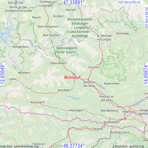
Mühldorf GPS coordinates[2]
46° 51' 37.008" North, 13° 21' 12.996" East
| Map corner | latitude | longitude |
|---|---|---|
| Upper-left | 47.33891°, | 12.65049° |
| Center: | 46.86028°, | 13.35361° |
| Lower-right: | 46.37734°, | 14.05674° |
| Map W x H: | 106.9×106.9 km | = 66.4×66.4mi |
| max Lat: | 48.98333° ⇑89.3% North |
| Mühldorf: | 46.86028° |
| min Lat: | ⇓10.7% South 46.48841° |
| min Long | Mühldorf | max Long |
| 9.57802° | 13.35361° | 17.1° |
| W 22.9%⇐ | ⇒77.1% E |
Elevation
Elevation of Mühldorf is 714 m = 2343 ft, and this is 208.5 m = 684 ft above average elevation for this country.
| Max E: |
2140 m = 7021 ft | 20.2% |
| Mühldorf | 714 m 2343 ft | |
| Avg. | 505.5 m = 1658 ft | |
Min E: |
118 m = 387 ft | 79.8% |
See also: Austria elevation on elevation.city.
Geographical zone
Mühldorf is located in North temperate zone (between Tropic of Cancer and the Arctic Circle). Distance of this North polar circle is 2190.8 km =1361.3 mi to North.| Distance of | km | miles | from Mühldorf |
|---|---|---|---|
| North Pole | 4796.7 | 2980.5 | to North |
| Arctic Circle | 2190.8 | 1361.3 | to North |
| Tropic Cancer | 2604.5 | 1618.4 | to South |
| Equator | 5210.4 | 3237.6 | to South |


Nearby cities:
15 places around Mühldorf: (largest is in red/bold)
• Baldramsdorf
10 km =6.2 mi,  130°
130°
• Gmünd
14.3 km =8.9 mi,  68°
68°
• Greifenburg
18 km =11.2 mi,  227°
227°
• Lendorf
6.5 km =4 mi,  115°
115°
• Lieserbrücke
10.3 km =6.4 mi,  106°
106°
• Lind
10.2 km =6.3 mi,  177°
177°
• Malta
15.7 km =9.8 mi,  48°
48°
• Möllbrücke
3 km =1.9 mi,  151°
151°
• Obervellach
14.2 km =8.8 mi,  306°
306°
• Pusarnitz
4.6 km =2.9 mi, 130°
• Sachsenburg
3.5 km =2.2 mi, 178°
• Seeboden
13.1 km =8.1 mi, 110°
• Spittal an der Drau
13 km =8.1 mi, 121°
• Steinfeld
13.9 km =8.6 mi,  214°
214°
• Trebesing
12.3 km =7.6 mi,  76°
76°
Sources, notices
• [Note1] Compared only with cities in Austria existing in our database
• [Src1] Map data: © OpenStreetMap contributors (CC-BY-SA)
• [Src2] Other city data from geonames.org with taken over terms of usage.
• [Src3] Geographical zone / Annual Mean Temperature by Robert A. Rohde @ Wikipedia
