Lendorf geodata
Lendorf (Carinthia) is a seat of a third-order administrative division; located in Austria in Europe/Vienna (GMT+2) time zone. With population of 920 people, there are 1398 cities with bigger population in this country. Compared to other cities in Austria, 90.2% of cities are located further ↑North; 76.2% of cities are located further →East and 70.2% of cities have lower elevation than Lendorf. Note1
Administrative division(s):
- Level 1: Carinthia
- Level 2: Politischer Bezirk Spittal an der Drau
- Level 3: Lendorf


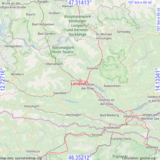
Lendorf GPS coordinates[2]
46° 50' 7.008" North, 13° 25' 49.008" East
| Map corner | latitude | longitude |
|---|---|---|
| Upper-left | 47.31413°, | 12.72716° |
| Center: | 46.83528°, | 13.43028° |
| Lower-right: | 46.35212°, | 14.13341° |
| Map W x H: | 107×107 km | = 66.5×66.5mi |
| max Lat: | 48.98333° ⇑90.2% North |
| Lendorf: | 46.83528° |
| min Lat: | ⇓9.8% South 46.48841° |
| min Long | Lendorf | max Long |
| 9.57802° | 13.43028° | 17.1° |
| W 23.8%⇐ | ⇒76.2% E |
Elevation
Elevation of Lendorf is 590 m = 1936 ft, and this is 84.5 m = 277 ft above average elevation for this country.
| Max E: |
2140 m = 7021 ft | 29.8% |
| Lendorf | 590 m 1936 ft | |
| Avg. | 505.5 m = 1658 ft | |
Min E: |
118 m = 387 ft | 70.2% |
See also: Austria elevation on elevation.city.
Geographical zone
Lendorf is located in North temperate zone (between Tropic of Cancer and the Arctic Circle). Distance of this North polar circle is 2193.6 km =1363 mi to North.| Distance of | km | miles | from Lendorf |
|---|---|---|---|
| North Pole | 4799.5 | 2982.3 | to North |
| Arctic Circle | 2193.6 | 1363 | to North |
| Tropic Cancer | 2601.7 | 1616.6 | to South |
| Equator | 5207.6 | 3235.9 | to South |


Nearby cities:
15 places around Lendorf: (largest is in red/bold)
• Baldramsdorf
4.2 km =2.6 mi,  155°
155°
• Gmünd
11 km =6.8 mi,  43°
43°
• Lieserbrücke
4 km =2.5 mi,  93°
93°
• Lind
9.1 km =5.7 mi,  215°
215°
• Malta
14.5 km =9 mi,  23°
23°
• Millstatt
11.9 km =7.4 mi,  106°
106°
• Möllbrücke
4.4 km =2.7 mi,  271°
271°
• Mühldorf
6.5 km =4 mi,  295°
295°
• Obermillstatt
13.3 km =8.3 mi,  100°
100°
• Pusarnitz
2.3 km =1.4 mi,  264°
264°
• Sachsenburg
5.8 km =3.6 mi, 263°
• Seeboden
6.6 km =4.1 mi, 105°
• Spittal an der Drau
6.6 km =4.1 mi,  126°
126°
• Stockenboi
14 km =8.7 mi,  149°
149°
• Trebesing
8.3 km =5.2 mi,  46°
46°
Sources, notices
• [Note1] Compared only with cities in Austria existing in our database
• [Src1] Map data: © OpenStreetMap contributors (CC-BY-SA)
• [Src2] Other city data from geonames.org with taken over terms of usage.
• [Src3] Geographical zone / Annual Mean Temperature by Robert A. Rohde @ Wikipedia
