Gmünd geodata
Gmünd (Carinthia) is a populated place; located in Austria in Europe/Vienna (GMT+2) time zone. With population of 1,317 people, there are 959 cities with bigger population in this country. Compared to other cities in Austria, 87.8% of cities are located further ↑North; 74.5% of cities are located further →East and 83% of cities have lower elevation than Gmünd. Note1
Administrative division(s):
- Level 1: Carinthia
- Level 2: Politischer Bezirk Spittal an der Drau
- Level 3: Gmünd in Kärnten


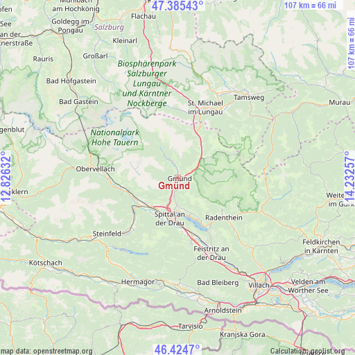
Gmünd GPS coordinates[2]
46° 54' 25.992" North, 13° 31' 45.984" East
| Map corner | latitude | longitude |
|---|---|---|
| Upper-left | 47.38543°, | 12.82632° |
| Center: | 46.90722°, | 13.52944° |
| Lower-right: | 46.4247°, | 14.23257° |
| Map W x H: | 106.8×106.8 km | = 66.4×66.4mi |
| max Lat: | 48.98333° ⇑87.8% North |
| Gmünd: | 46.90722° |
| min Lat: | ⇓12.2% South 46.48841° |
| min Long | Gmünd | max Long |
| 9.57802° | 13.52944° | 17.1° |
| W 25.5%⇐ | ⇒74.5% E |
Elevation
Elevation of Gmünd is 768 m = 2520 ft, and this is 262.5 m = 861 ft above average elevation for this country.
| Max E: |
2140 m = 7021 ft | 17% |
| Gmünd | 768 m 2520 ft | |
| Avg. | 505.5 m = 1658 ft | |
Min E: |
118 m = 387 ft | 83% |
See also: Austria elevation on elevation.city.
Geographical zone
Gmünd is located in North temperate zone (between Tropic of Cancer and the Arctic Circle). Distance of this North polar circle is 2185.6 km =1358.1 mi to North.| Distance of | km | miles | from Gmünd |
|---|---|---|---|
| North Pole | 4791.5 | 2977.3 | to North |
| Arctic Circle | 2185.6 | 1358.1 | to North |
| Tropic Cancer | 2609.7 | 1621.6 | to South |
| Equator | 5215.6 | 3240.8 | to South |


Nearby cities:
15 places around Gmünd: (largest is in red/bold)
• Baldramsdorf
13.1 km =8.1 mi,  206°
206°
• Kaning
16.3 km =10.1 mi,  123°
123°
• Lendorf
11 km =6.8 mi,  223°
223°
• Lieserbrücke
8.9 km =5.5 mi,  203°
203°
• Malta
5.5 km =3.4 mi,  342°
342°
• Millstatt
12.1 km =7.5 mi,  161°
161°
• Möllbrücke
14.3 km =8.9 mi,  236°
236°
• Mühldorf
14.3 km =8.9 mi,  248°
248°
• Obermillstatt
11.8 km =7.3 mi,  152°
152°
• Pusarnitz
12.8 km =8 mi,  230°
230°
• Rennweg am Katschberg
13.9 km =8.6 mi,  28°
28°
• Sachsenburg
15.8 km =9.8 mi, 236°
• Seeboden
9.9 km =6.2 mi,  186°
186°
• Spittal an der Drau
12.1 km =7.5 mi, 190°
• Trebesing
2.7 km =1.7 mi, 212°
Sources, notices
• [Note1] Compared only with cities in Austria existing in our database
• [Src1] Map data: © OpenStreetMap contributors (CC-BY-SA)
• [Src2] Other city data from geonames.org with taken over terms of usage.
• [Src3] Geographical zone / Annual Mean Temperature by Robert A. Rohde @ Wikipedia
