Moschendorf geodata
Moschendorf (Burgenland) is a seat of a third-order administrative division; located in Austria in Europe/Vienna (GMT+1) time zone. With population of 400 people, there are 2619 cities with bigger population in this country. Compared to other cities in Austria, 81.6% of cities are located further ↑North; 93.2% of cities are located further ←West and 91.2% of cities have higher elevation than Moschendorf. Note1
Administrative division(s):
- Level 1: Burgenland
- Level 2: Politischer Bezirk Güssing
- Level 3: Moschendorf


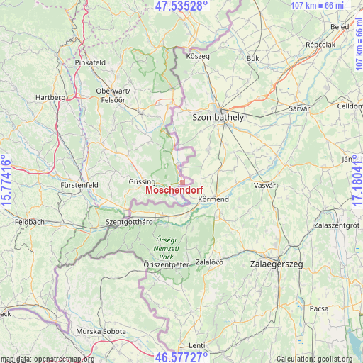
Moschendorf GPS coordinates[2]
47° 3' 30.348" North, 16° 28' 38.208" East
| Map corner | latitude | longitude |
|---|---|---|
| Upper-left | 47.53528°, | 15.77416° |
| Center: | 47.05843°, | 16.47728° |
| Lower-right: | 46.57727°, | 17.18041° |
| Map W x H: | 106.5×106.5 km | = 66.2×66.2mi |
| max Lat: | 48.98333° ⇑81.6% North |
| Moschendorf: | 47.05843° |
| min Lat: | ⇓18.4% South 46.48841° |
| min Long | Moschendorf | max Long |
| 9.57802° | 16.47728° | 17.1° |
| W 93.2%⇐ | ⇒6.8% E |
Elevation
Elevation of Moschendorf is 206 m = 676 ft, and this is 299.5 m = 983 ft below average elevation for this country.
| Max E: |
2140 m = 7021 ft | 91.2% |
| Avg. | 505.5 m = 1658 ft | |
| Moschendorf | 206 m = 676 ft | |
Min E: |
118 m = 387 ft | 8.8% |
See also: Austria elevation on elevation.city.
Geographical zone
Moschendorf is located in North temperate zone (between Tropic of Cancer and the Arctic Circle). Distance of this North polar circle is 2168.8 km =1347.6 mi to North.| Distance of | km | miles | from Moschendorf |
|---|---|---|---|
| North Pole | 4774.7 | 2966.9 | to North |
| Arctic Circle | 2168.8 | 1347.6 | to North |
| Tropic Cancer | 2626.5 | 1632 | to South |
| Equator | 5232.4 | 3251.3 | to South |


Nearby cities:
15 places around Moschendorf: (largest is in red/bold)
• Badersdorf
17.8 km =11.1 mi,  332°
332°
• Deutsch Tschantschendorf
15.4 km =9.6 mi,  287°
287°
• Eberau
5.6 km =3.5 mi,  346°
346°
• Güssing
11.6 km =7.2 mi,  270°
270°
• Güttenbach
17.8 km =11.1 mi,  308°
308°
• Heiligenbrunn
5.8 km =3.6 mi,  232°
232°
• Heiligenkreuz im Lafnitztal
18.1 km =11.2 mi,  244°
244°
• Inzenhof
13 km =8.1 mi,  249°
249°
• Kleinmürbisch
11.9 km =7.4 mi,  256°
256°
• Kohfidisch
15.8 km =9.8 mi,  324°
324°
• Neustift bei Güssing
16.9 km =10.5 mi, 257°
• Sankt Michael im Burgenland
17.4 km =10.8 mi,  296°
296°
• Strem
5 km =3.1 mi, 252°
• Tobaj
13.7 km =8.5 mi,  281°
281°
• Tschanigraben
14.2 km =8.8 mi, 250°
Sources, notices
• [Note1] Compared only with cities in Austria existing in our database
• [Src1] Map data: © OpenStreetMap contributors (CC-BY-SA)
• [Src2] Other city data from geonames.org with taken over terms of usage.
• [Src3] Geographical zone / Annual Mean Temperature by Robert A. Rohde @ Wikipedia
