Strem geodata
Strem (Burgenland) is a seat of a third-order administrative division; located in Austria in Europe/Vienna (GMT+2) time zone. With population of 599 people, there are 2144 cities with bigger population in this country. Compared to other cities in Austria, 82.3% of cities are located further ↑North; 91.6% of cities are located further ←West and 90.7% of cities have higher elevation than Strem. Note1


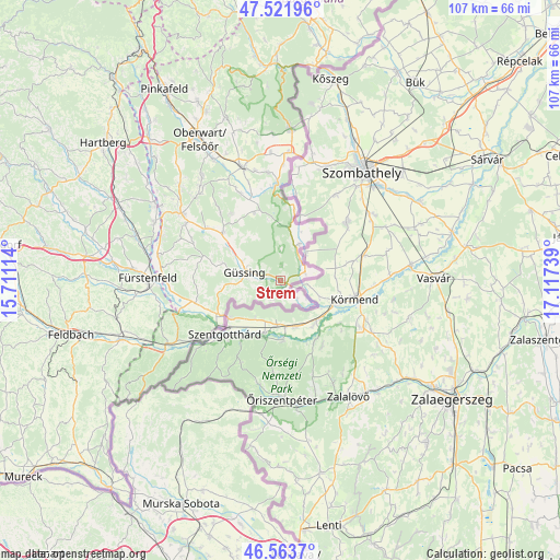
Strem GPS coordinates[2]
47° 2' 41.928" North, 16° 24' 51.336" East
| Map corner | latitude | longitude |
|---|---|---|
| Upper-left | 47.52196°, | 15.71114° |
| Center: | 47.04498°, | 16.41426° |
| Lower-right: | 46.5637°, | 17.11739° |
| Map W x H: | 106.5×106.5 km | = 66.2×66.2mi |
| max Lat: | 48.98333° ⇑82.3% North |
| Strem: | 47.04498° |
| min Lat: | ⇓17.7% South 46.48841° |
| min Long | Strem | max Long |
| 9.57802° | 16.41426° | 17.1° |
| W 91.6%⇐ | ⇒8.4% E |
Elevation
Elevation of Strem is 209 m = 686 ft, and this is 296.5 m = 973 ft below average elevation for this country.
| Max E: |
2140 m = 7021 ft | 90.7% |
| Avg. | 505.5 m = 1658 ft | |
| Strem | 209 m = 686 ft | |
Min E: |
118 m = 387 ft | 9.3% |
See also: Austria elevation on elevation.city.
Geographical zone
Strem is located in North temperate zone (between Tropic of Cancer and the Arctic Circle). Distance of this North polar circle is 2170.3 km =1348.6 mi to North.| Distance of | km | miles | from Strem |
|---|---|---|---|
| North Pole | 4776.2 | 2967.8 | to North |
| Arctic Circle | 2170.3 | 1348.6 | to North |
| Tropic Cancer | 2625 | 1631.1 | to South |
| Equator | 5230.9 | 3250.3 | to South |


Nearby cities:
15 places around Strem: (largest is in red/bold)
• Deutsch Tschantschendorf
11.7 km =7.3 mi,  301°
301°
• Eberau
7.8 km =4.8 mi,  26°
26°
• Güssing
7 km =4.3 mi,  283°
283°
• Güttenbach
15.5 km =9.6 mi,  323°
323°
• Heiligenbrunn
2 km =1.2 mi,  174°
174°
• Heiligenkreuz im Lafnitztal
13.2 km =8.2 mi,  241°
241°
• Inzenhof
8 km =5 mi,  246°
246°
• Kleinmürbisch
6.9 km =4.3 mi,  258°
258°
• Kohfidisch
15.1 km =9.4 mi,  343°
343°
• Kukmirn
15.8 km =9.8 mi, 282°
• Moschendorf
5 km =3.1 mi,  72°
72°
• Neustift bei Güssing
11.9 km =7.4 mi, 259°
• Sankt Michael im Burgenland
14.3 km =8.9 mi,  310°
310°
• Tobaj
9.6 km =6 mi, 296°
• Tschanigraben
9.2 km =5.7 mi, 250°
Sources, notices
• [Note1] Compared only with cities in Austria existing in our database
• [Src1] Map data: © OpenStreetMap contributors (CC-BY-SA)
• [Src2] Other city data from geonames.org with taken over terms of usage.
• [Src3] Geographical zone / Annual Mean Temperature by Robert A. Rohde @ Wikipedia
