Eberau geodata
Eberau (Burgenland) is a seat of a third-order administrative division; located in Austria in Europe/Vienna (GMT+2) time zone. With population of 366 people, there are 2661 cities with bigger population in this country. Compared to other cities in Austria, 78.6% of cities are located further ↑North; 92.7% of cities are located further ←West and 89.6% of cities have higher elevation than Eberau. Note1


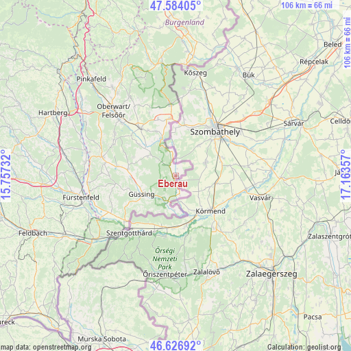
Eberau GPS coordinates[2]
47° 6' 27.504" North, 16° 27' 37.584" East
| Map corner | latitude | longitude |
|---|---|---|
| Upper-left | 47.58405°, | 15.75732° |
| Center: | 47.10764°, | 16.46044° |
| Lower-right: | 46.62692°, | 17.16357° |
| Map W x H: | 106.4×106.4 km | = 66.1×66.1mi |
| max Lat: | 48.98333° ⇑78.6% North |
| Eberau: | 47.10764° |
| min Lat: | ⇓21.4% South 46.48841° |
| min Long | Eberau | max Long |
| 9.57802° | 16.46044° | 17.1° |
| W 92.7%⇐ | ⇒7.3% E |
Elevation
Elevation of Eberau is 215 m = 705 ft, and this is 290.5 m = 953 ft below average elevation for this country.
| Max E: |
2140 m = 7021 ft | 89.6% |
| Avg. | 505.5 m = 1658 ft | |
| Eberau | 215 m = 705 ft | |
Min E: |
118 m = 387 ft | 10.4% |
See also: Austria elevation on elevation.city.
Geographical zone
Eberau is located in North temperate zone (between Tropic of Cancer and the Arctic Circle). Distance of this North polar circle is 2163.3 km =1344.2 mi to North.| Distance of | km | miles | from Eberau |
|---|---|---|---|
| North Pole | 4769.2 | 2963.4 | to North |
| Arctic Circle | 2163.3 | 1344.2 | to North |
| Tropic Cancer | 2632 | 1635.4 | to South |
| Equator | 5237.9 | 3254.7 | to South |


Nearby cities:
15 places around Eberau: (largest is in red/bold)
• Badersdorf
12.5 km =7.8 mi,  325°
325°
• Deutsch Tschantschendorf
13.4 km =8.3 mi,  266°
266°
• Güssing
11.6 km =7.2 mi,  242°
242°
• Güttenbach
13.9 km =8.6 mi,  293°
293°
• Hannersdorf
14.7 km =9.1 mi,  336°
336°
• Heiligenbrunn
9.5 km =5.9 mi,  200°
200°
• Inzenhof
14.9 km =9.3 mi,  227°
227°
• Kleinmürbisch
13.2 km =8.2 mi, 231°
• Kohfidisch
10.8 km =6.7 mi,  313°
313°
• Mischendorf
14.5 km =9 mi, 310°
• Moschendorf
5.6 km =3.5 mi,  166°
166°
• Sankt Michael im Burgenland
14.5 km =9 mi,  279°
279°
• Schandorf
15.2 km =9.4 mi,  349°
349°
• Strem
7.8 km =4.8 mi,  206°
206°
• Tobaj
12.4 km =7.7 mi,  257°
257°
Sources, notices
• [Note1] Compared only with cities in Austria existing in our database
• [Src1] Map data: © OpenStreetMap contributors (CC-BY-SA)
• [Src2] Other city data from geonames.org with taken over terms of usage.
• [Src3] Geographical zone / Annual Mean Temperature by Robert A. Rohde @ Wikipedia
