Mittersill geodata
Mittersill (Salzburg) is a seat of a third-order administrative division; located in Austria in Europe/Vienna (GMT+2) time zone. With population of 1,888 people, there are 657 cities with bigger population in this country. Compared to other cities in Austria, 67.2% of cities are located further ↑North; 86.2% of cities are located further →East and 84.3% of cities have lower elevation than Mittersill. Note1
Administrative division(s):
- Level 1: Salzburg
- Level 2: Politischer Bezirk Zell am See
- Level 3: Mittersill


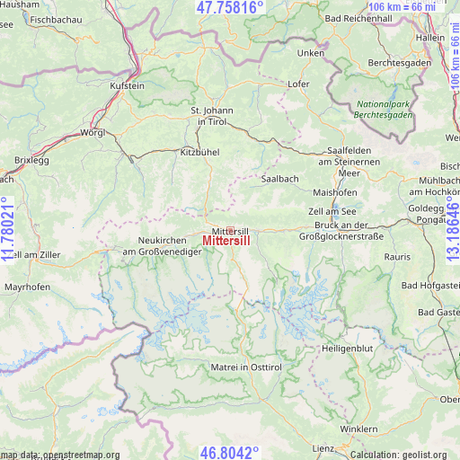
Mittersill GPS coordinates[2]
47° 16' 59.988" North, 12° 28' 59.988" East
| Map corner | latitude | longitude |
|---|---|---|
| Upper-left | 47.75816°, | 11.78021° |
| Center: | 47.28333°, | 12.48333° |
| Lower-right: | 46.8042°, | 13.18646° |
| Map W x H: | 106.1×106.1 km | = 65.9×65.9mi |
| max Lat: | 48.98333° ⇑67.2% North |
| Mittersill: | 47.28333° |
| min Lat: | ⇓32.8% South 46.48841° |
| min Long | Mittersill | max Long |
| 9.57802° | 12.48333° | 17.1° |
| W 13.8%⇐ | ⇒86.2% E |
Elevation
Elevation of Mittersill is 786 m = 2579 ft, and this is 280.5 m = 920 ft above average elevation for this country.
| Max E: |
2140 m = 7021 ft | 15.7% |
| Mittersill | 786 m 2579 ft | |
| Avg. | 505.5 m = 1658 ft | |
Min E: |
118 m = 387 ft | 84.3% |
See also: Austria elevation on elevation.city.
Geographical zone
Mittersill is located in North temperate zone (between Tropic of Cancer and the Arctic Circle). Distance of this North polar circle is 2143.8 km =1332.1 mi to North.| Distance of | km | miles | from Mittersill |
|---|---|---|---|
| North Pole | 4749.6 | 2951.3 | to North |
| Arctic Circle | 2143.8 | 1332.1 | to North |
| Tropic Cancer | 2651.5 | 1647.6 | to South |
| Equator | 5257.4 | 3266.8 | to South |


Nearby cities:
15 places around Mittersill: (largest is in red/bold)
• Aurach
14.9 km =9.3 mi,  343°
343°
• Bramberg am Wildkogel
11 km =6.8 mi,  262°
262°
• Burk
1 km =0.6 mi,  61°
61°
• Felben
0 km =0 mi,  0°
0°
• Hinterglemm
13.4 km =8.3 mi,  39°
39°
• Hollersbach im Pinzgau
4.6 km =2.9 mi, 260°
• Jochberg
11.7 km =7.3 mi, 335°
• Neukirchen am Großvenediger
16.1 km =10 mi, 256°
• Niedernsill
12.6 km =7.8 mi,  90°
90°
• Piesendorf
17.7 km =11 mi, 87°
• Saalbach
16.7 km =10.4 mi, 43°
• Steindorf
12.1 km =7.5 mi, 88°
• Stuhlfelden
3.4 km =2.1 mi,  81°
81°
• Uttendorf
6.3 km =3.9 mi, 90°
• Walchen
15.4 km =9.6 mi, 87°
Sources, notices
• [Note1] Compared only with cities in Austria existing in our database
• [Src1] Map data: © OpenStreetMap contributors (CC-BY-SA)
• [Src2] Other city data from geonames.org with taken over terms of usage.
• [Src3] Geographical zone / Annual Mean Temperature by Robert A. Rohde @ Wikipedia
