Jochberg geodata
Jochberg (Tyrol) is a seat of a third-order administrative division; located in Austria in Europe/Vienna (GMT+2) time zone. With population of 1,577 people, there are 792 cities with bigger population in this country. Compared to other cities in Austria, 61.1% of cities are located further ↑North; 86.6% of cities are located further →East and 92.3% of cities have lower elevation than Jochberg. Note1


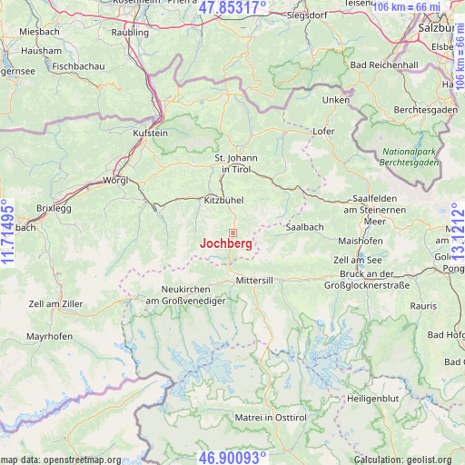
Jochberg GPS coordinates[2]
47° 22' 45.12" North, 12° 25' 5.052" East
| Map corner | latitude | longitude |
|---|---|---|
| Upper-left | 47.85317°, | 11.71495° |
| Center: | 47.3792°, | 12.41807° |
| Lower-right: | 46.90093°, | 13.1212° |
| Map W x H: | 105.9×105.9 km | = 65.8×65.8mi |
| max Lat: | 48.98333° ⇑61.1% North |
| Jochberg: | 47.3792° |
| min Lat: | ⇓38.9% South 46.48841° |
| min Long | Jochberg | max Long |
| 9.57802° | 12.41807° | 17.1° |
| W 13.4%⇐ | ⇒86.6% E |
Elevation
Elevation of Jochberg is 931 m = 3054 ft, and this is 425.5 m = 1396 ft above average elevation for this country.
| Max E: |
2140 m = 7021 ft | 7.7% |
| Jochberg | 931 m 3054 ft | |
| Avg. | 505.5 m = 1658 ft | |
Min E: |
118 m = 387 ft | 92.3% |
See also: Austria elevation on elevation.city.
Geographical zone
Jochberg is located in North temperate zone (between Tropic of Cancer and the Arctic Circle). Distance of this North polar circle is 2133.1 km =1325.4 mi to North.| Distance of | km | miles | from Jochberg |
|---|---|---|---|
| North Pole | 4739 | 2944.7 | to North |
| Arctic Circle | 2133.1 | 1325.4 | to North |
| Tropic Cancer | 2662.2 | 1654.2 | to South |
| Equator | 5268.1 | 3273.4 | to South |


Nearby cities:
15 places around Jochberg: (largest is in red/bold)
• Aurach
3.7 km =2.3 mi,  10°
10°
• Bramberg am Wildkogel
13.6 km =8.5 mi,  206°
206°
• Brixen im Thale
14.9 km =9.3 mi,  301°
301°
• Burk
11.7 km =7.3 mi,  150°
150°
• Felben
11.7 km =7.3 mi,  155°
155°
• Fieberbrunn
14.3 km =8.9 mi,  41°
41°
• Hinterglemm
13.4 km =8.3 mi,  91°
91°
• Hollersbach im Pinzgau
11.4 km =7.1 mi,  178°
178°
• Kirchberg in Tirol
10.6 km =6.6 mi,  313°
313°
• Kitzbühel
7.7 km =4.8 mi,  345°
345°
• Mittersill
11.7 km =7.3 mi, 155°
• Oberndorf in Tirol
13.7 km =8.5 mi, 348°
• Reith bei Kitzbühel
11 km =6.8 mi,  332°
332°
• Stuhlfelden
13.1 km =8.1 mi,  140°
140°
• Uttendorf
15.5 km =9.6 mi,  133°
133°
Sources, notices
• [Note1] Compared only with cities in Austria existing in our database
• [Src1] Map data: © OpenStreetMap contributors (CC-BY-SA)
• [Src2] Other city data from geonames.org with taken over terms of usage.
• [Src3] Geographical zone / Annual Mean Temperature by Robert A. Rohde @ Wikipedia
