Mining geodata
Mining (Upper Austria) is a populated place; located in Austria in Europe/Vienna (GMT+2) time zone. With population of 655 people, there are 1970 cities with bigger population in this country. Compared to other cities in Austria, 84.4% of cities are located further ↓South; 79.9% of cities are located further →East and 66.2% of cities have higher elevation than Mining. Note1
Administrative division(s):
- Level 1: Upper Austria
- Level 2: Politischer Bezirk Braunau am Inn
- Level 3: Mining


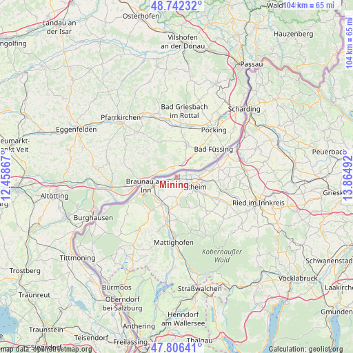
Mining GPS coordinates[2]
48° 16' 35.436" North, 13° 9' 42.444" East
| Map corner | latitude | longitude |
|---|---|---|
| Upper-left | 48.74232°, | 12.45867° |
| Center: | 48.27651°, | 13.16179° |
| Lower-right: | 47.80641°, | 13.86492° |
| Map W x H: | 104.1×104.1 km | = 64.7×64.7mi |
| max Lat: | 48.98333° ⇑15.6% North |
| Mining: | 48.27651° |
| min Lat: | ⇓84.4% South 46.48841° |
| min Long | Mining | max Long |
| 9.57802° | 13.16179° | 17.1° |
| W 20.1%⇐ | ⇒79.9% E |
Elevation
Elevation of Mining is 347 m = 1138 ft, and this is 158.5 m = 520 ft below average elevation for this country.
| Max E: |
2140 m = 7021 ft | 66.2% |
| Avg. | 505.5 m = 1658 ft | |
| Mining | 347 m = 1138 ft | |
Min E: |
118 m = 387 ft | 33.8% |
See also: Austria elevation on elevation.city.
Geographical zone
Mining is located in North temperate zone (between Tropic of Cancer and the Arctic Circle). Distance of this North polar circle is 2033.3 km =1263.4 mi to North.| Distance of | km | miles | from Mining |
|---|---|---|---|
| North Pole | 4639.2 | 2882.7 | to North |
| Arctic Circle | 2033.3 | 1263.4 | to North |
| Tropic Cancer | 2761.9 | 1716.2 | to South |
| Equator | 5367.8 | 3335.4 | to South |


Nearby cities:
15 places around Mining: (largest is in red/bold)
• Altheim
6 km =3.7 mi,  117°
117°
• Braunau Neustadt
9.9 km =6.2 mi,  250°
250°
• Braunau am Inn
9 km =5.6 mi,  255°
255°
• Burgkirchen
9.2 km =5.7 mi,  209°
209°
• Geinberg
9.9 km =6.2 mi,  98°
98°
• Haselbach
8.2 km =5.1 mi, 251°
• Laab
8.1 km =5 mi, 257°
• Mauerkirchen
9.7 km =6 mi,  192°
192°
• Neue Heimat
9.5 km =5.9 mi, 248°
• Osternberg
10.5 km =6.5 mi, 250°
• Polling im Innkreis
10.1 km =6.3 mi, 119°
• Ranshofen
11.8 km =7.3 mi, 245°
• Sankt Peter am Hart
5.5 km =3.4 mi,  241°
241°
• Treubach
9.7 km =6 mi,  157°
157°
• Weng im Innkreis
4.8 km =3 mi,  165°
165°
Sources, notices
• [Note1] Compared only with cities in Austria existing in our database
• [Src1] Map data: © OpenStreetMap contributors (CC-BY-SA)
• [Src2] Other city data from geonames.org with taken over terms of usage.
• [Src3] Geographical zone / Annual Mean Temperature by Robert A. Rohde @ Wikipedia
