Treubach geodata
Treubach (Upper Austria) is a populated place; located in Austria in Europe/Vienna (GMT+2) time zone. With population of 716 people, there are 1815 cities with bigger population in this country. Compared to other cities in Austria, 78.9% of cities are located further ↓South; 78.9% of cities are located further →East and 56.8% of cities have higher elevation than Treubach. Note1
Administrative division(s):
- Level 1: Upper Austria
- Level 2: Politischer Bezirk Braunau am Inn
- Level 3: Treubach


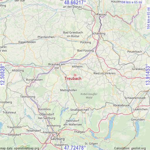
Treubach GPS coordinates[2]
48° 11' 44.232" North, 13° 12' 41.04" East
| Map corner | latitude | longitude |
|---|---|---|
| Upper-left | 48.66217°, | 12.50828° |
| Center: | 48.19562°, | 13.2114° |
| Lower-right: | 47.72478°, | 13.91453° |
| Map W x H: | 104.2×104.2 km | = 64.7×64.7mi |
| max Lat: | 48.98333° ⇑21.1% North |
| Treubach: | 48.19562° |
| min Lat: | ⇓78.9% South 46.48841° |
| min Long | Treubach | max Long |
| 9.57802° | 13.2114° | 17.1° |
| W 21.1%⇐ | ⇒78.9% E |
Elevation
Elevation of Treubach is 406 m = 1332 ft, and this is 99.5 m = 326 ft below average elevation for this country.
| Max E: |
2140 m = 7021 ft | 56.8% |
| Avg. | 505.5 m = 1658 ft | |
| Treubach | 406 m = 1332 ft | |
Min E: |
118 m = 387 ft | 43.2% |
See also: Austria elevation on elevation.city.
Geographical zone
Treubach is located in North temperate zone (between Tropic of Cancer and the Arctic Circle). Distance of this North polar circle is 2042.3 km =1269 mi to North.| Distance of | km | miles | from Treubach |
|---|---|---|---|
| North Pole | 4648.2 | 2888.3 | to North |
| Arctic Circle | 2042.3 | 1269 | to North |
| Tropic Cancer | 2752.9 | 1710.6 | to South |
| Equator | 5358.9 | 3329.9 | to South |


Nearby cities:
15 places around Treubach: (largest is in red/bold)
• Altheim
6.4 km =4 mi,  15°
15°
• Aspach
7 km =4.3 mi,  99°
99°
• Burgkirchen
8.3 km =5.2 mi,  276°
276°
• Geinberg
9.8 km =6.1 mi,  38°
38°
• Höfen
7.9 km =4.9 mi,  231°
231°
• Maria Schmolln
6.4 km =4 mi,  174°
174°
• Mattighofen
10.8 km =6.7 mi,  204°
204°
• Mauerkirchen
5.8 km =3.6 mi,  265°
265°
• Mining
9.7 km =6 mi,  337°
337°
• Polling im Innkreis
6.4 km =4 mi,  52°
52°
• Sankt Peter am Hart
10.6 km =6.6 mi,  306°
306°
• Schalchen
9.4 km =5.8 mi,  205°
205°
• Uttendorf
7.8 km =4.8 mi,  238°
238°
• Weng im Innkreis
5 km =3.1 mi,  330°
330°
• Wildenau
7.9 km =4.9 mi,  81°
81°
Sources, notices
• [Note1] Compared only with cities in Austria existing in our database
• [Src1] Map data: © OpenStreetMap contributors (CC-BY-SA)
• [Src2] Other city data from geonames.org with taken over terms of usage.
• [Src3] Geographical zone / Annual Mean Temperature by Robert A. Rohde @ Wikipedia
