Krispl geodata
Krispl (Salzburg) is a seat of a third-order administrative division; located in Austria in Europe/Vienna (GMT+2) time zone. With population of 110 people, there are 2921 cities with bigger population in this country. Compared to other cities in Austria, 54.1% of cities are located further ↓South; 79.5% of cities are located further →East and 87.5% of cities have lower elevation than Krispl. Note1


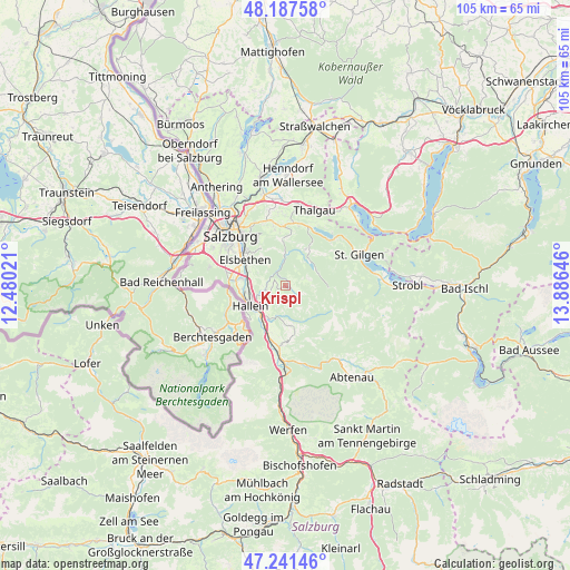
Krispl GPS coordinates[2]
47° 43' 0.012" North, 13° 10' 59.988" East
| Map corner | latitude | longitude |
|---|---|---|
| Upper-left | 48.18758°, | 12.48021° |
| Center: | 47.71667°, | 13.18333° |
| Lower-right: | 47.24146°, | 13.88646° |
| Map W x H: | 105.2×105.2 km | = 65.4×65.4mi |
| max Lat: | 48.98333° ⇑45.9% North |
| Krispl: | 47.71667° |
| min Lat: | ⇓54.1% South 46.48841° |
| min Long | Krispl | max Long |
| 9.57802° | 13.18333° | 17.1° |
| W 20.5%⇐ | ⇒79.5% E |
Elevation
Elevation of Krispl is 838 m = 2749 ft, and this is 332.5 m = 1091 ft above average elevation for this country.
| Max E: |
2140 m = 7021 ft | 12.5% |
| Krispl | 838 m 2749 ft | |
| Avg. | 505.5 m = 1658 ft | |
Min E: |
118 m = 387 ft | 87.5% |
See also: Austria elevation on elevation.city.
Geographical zone
Krispl is located in North temperate zone (between Tropic of Cancer and the Arctic Circle). Distance of this North polar circle is 2095.6 km =1302.1 mi to North.| Distance of | km | miles | from Krispl |
|---|---|---|---|
| North Pole | 4701.5 | 2921.4 | to North |
| Arctic Circle | 2095.6 | 1302.1 | to North |
| Tropic Cancer | 2699.7 | 1677.5 | to South |
| Equator | 5305.6 | 3296.7 | to South |


Nearby cities:
15 places around Krispl: (largest is in red/bold)
• Adnet
4.5 km =2.8 mi,  241°
241°
• Anger
6.7 km =4.2 mi,  33°
33°
• Burgfried
6.7 km =4.2 mi,  232°
232°
• Faistenau
7.8 km =4.8 mi, 29°
• Gaißau
1.3 km =0.8 mi,  119°
119°
• Hallein
7.3 km =4.5 mi, 239°
• Hintersee
7.7 km =4.8 mi,  103°
103°
• Neualm
7.6 km =4.7 mi,  250°
250°
• Oberalm
6.5 km =4 mi, 253°
• Puch bei Hallein
6.8 km =4.2 mi,  268°
268°
• Taugl
7.8 km =4.8 mi,  169°
169°
• Vigaun
6.7 km =4.2 mi,  213°
213°
• Vordersee
6.2 km =3.9 mi,  53°
53°
• Waidach
4.6 km =2.9 mi, 227°
• Wimberg
2.4 km =1.5 mi, 270°
Sources, notices
• [Note1] Compared only with cities in Austria existing in our database
• [Src1] Map data: © OpenStreetMap contributors (CC-BY-SA)
• [Src2] Other city data from geonames.org with taken over terms of usage.
• [Src3] Geographical zone / Annual Mean Temperature by Robert A. Rohde @ Wikipedia
