Rötz geodata
Rötz (Styria) is a populated place; located in Austria in Europe/Vienna (GMT+2) time zone. With population of 768 people, there are 1683 cities with bigger population in this country. Compared to other cities in Austria, 78.3% of cities are located further ↑North; 60.5% of cities are located further ←West and 56.8% of cities have higher elevation than Rötz. Note1
Administrative division(s):
- Level 1: Styria
- Level 2: Politischer Bezirk Graz-Umgebung
- Level 3: Gratwein-Straßengel


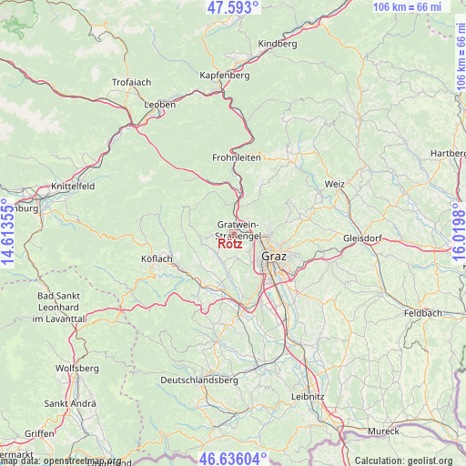
Rötz GPS coordinates[2]
47° 7' 0.012" North, 15° 19' 0.012" East
| Map corner | latitude | longitude |
|---|---|---|
| Upper-left | 47.593°, | 14.61355° |
| Center: | 47.11667°, | 15.31667° |
| Lower-right: | 46.63604°, | 16.0198° |
| Map W x H: | 106.4×106.4 km | = 66.1×66.1mi |
| max Lat: | 48.98333° ⇑78.3% North |
| Rötz: | 47.11667° |
| min Lat: | ⇓21.7% South 46.48841° |
| min Long | Rötz | max Long |
| 9.57802° | 15.31667° | 17.1° |
| W 60.5%⇐ | ⇒39.5% E |
Elevation
Elevation of Rötz is 406 m = 1332 ft, and this is 99.5 m = 326 ft below average elevation for this country.
| Max E: |
2140 m = 7021 ft | 56.8% |
| Avg. | 505.5 m = 1658 ft | |
| Rötz | 406 m = 1332 ft | |
Min E: |
118 m = 387 ft | 43.2% |
See also: Austria elevation on elevation.city.
Geographical zone
Rötz is located in North temperate zone (between Tropic of Cancer and the Arctic Circle). Distance of this North polar circle is 2162.3 km =1343.6 mi to North.| Distance of | km | miles | from Rötz |
|---|---|---|---|
| North Pole | 4768.2 | 2962.8 | to North |
| Arctic Circle | 2162.3 | 1343.6 | to North |
| Tropic Cancer | 2633 | 1636.1 | to South |
| Equator | 5238.9 | 3255.3 | to South |


Nearby cities:
15 places around Rötz: (largest is in red/bold)
• Eisbach
3.8 km =2.4 mi,  270°
270°
• Forstviertel
4.5 km =2.8 mi,  34°
34°
• Gratkorn
3.1 km =1.9 mi,  53°
53°
• Gratwein
0 km =0 mi,  0°
0°
• Gösting
6.5 km =4 mi,  108°
108°
• Hörgas
3.9 km =2.4 mi,  341°
341°
• Jaritzberg
6.3 km =3.9 mi,  233°
233°
• Judendorf
2.5 km =1.6 mi,  90°
90°
• Kirchenviertel
2.8 km =1.7 mi,  55°
55°
• Plankenwarth
3.1 km =1.9 mi,  187°
187°
• Rein
3.1 km =1.9 mi,  306°
306°
• Sankt Oswald bei Plankenwarth
4.5 km =2.8 mi,  222°
222°
• Steinberg
5.6 km =3.5 mi,  180°
180°
• Strassengel
1.2 km =0.7 mi, 94°
• Thal
5.6 km =3.5 mi,  143°
143°
Sources, notices
• [Note1] Compared only with cities in Austria existing in our database
• [Src1] Map data: © OpenStreetMap contributors (CC-BY-SA)
• [Src2] Other city data from geonames.org with taken over terms of usage.
• [Src3] Geographical zone / Annual Mean Temperature by Robert A. Rohde @ Wikipedia
