Jaritzberg geodata
Jaritzberg (Styria) is a populated place; located in Austria in Europe/Vienna (GMT+2) time zone. With population of 573 people, there are 2236 cities with bigger population in this country. Compared to other cities in Austria, 80.3% of cities are located further ↑North; 58.7% of cities are located further ←West and 59.7% of cities have lower elevation than Jaritzberg. Note1
Administrative division(s):
- Level 1: Styria
- Level 2: Politischer Bezirk Graz-Umgebung
- Level 3: Sankt Bartholomä


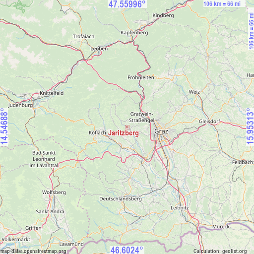
Jaritzberg GPS coordinates[2]
47° 4' 59.988" North, 15° 15' 0" East
| Map corner | latitude | longitude |
|---|---|---|
| Upper-left | 47.55996°, | 14.54688° |
| Center: | 47.08333°, | 15.25° |
| Lower-right: | 46.6024°, | 15.95313° |
| Map W x H: | 106.5×106.5 km | = 66.2×66.2mi |
| max Lat: | 48.98333° ⇑80.3% North |
| Jaritzberg: | 47.08333° |
| min Lat: | ⇓19.7% South 46.48841° |
| min Long | Jaritzberg | max Long |
| 9.57802° | 15.25° | 17.1° |
| W 58.7%⇐ | ⇒41.3% E |
Elevation
Elevation of Jaritzberg is 516 m = 1693 ft, and this is 10.5 m = 34 ft above average elevation for this country.
| Max E: |
2140 m = 7021 ft | 40.3% |
| Jaritzberg | 516 m 1693 ft | |
| Avg. | 505.5 m = 1658 ft | |
Min E: |
118 m = 387 ft | 59.7% |
See also: Austria elevation on elevation.city.
Geographical zone
Jaritzberg is located in North temperate zone (between Tropic of Cancer and the Arctic Circle). Distance of this North polar circle is 2166 km =1345.9 mi to North.| Distance of | km | miles | from Jaritzberg |
|---|---|---|---|
| North Pole | 4771.9 | 2965.1 | to North |
| Arctic Circle | 2166 | 1345.9 | to North |
| Tropic Cancer | 2629.3 | 1633.8 | to South |
| Equator | 5235.2 | 3253 | to South |


Nearby cities:
15 places around Jaritzberg: (largest is in red/bold)
• Eisbach
3.9 km =2.4 mi,  18°
18°
• Gratwein
6.3 km =3.9 mi,  53°
53°
• Hitzendorf
6.7 km =4.2 mi,  145°
145°
• Kleingaisfeld
7.1 km =4.4 mi,  204°
204°
• Plankenwarth
4.7 km =2.9 mi,  81°
81°
• Rein
6.1 km =3.8 mi, 24°
• Rohrbach
4.5 km =2.8 mi, 145°
• Rötz
6.3 km =3.9 mi, 53°
• Sankt Bartholomä
3.3 km =2.1 mi,  168°
168°
• Sankt Oswald bei Plankenwarth
2.1 km =1.3 mi, 78°
• Stallhofen
4.5 km =2.8 mi,  214°
214°
• Steinberg
5.4 km =3.4 mi,  110°
110°
• Stiwoll
3.1 km =1.9 mi,  306°
306°
• Strassengel
7.2 km =4.5 mi,  60°
60°
• Södingberg
6.5 km =4 mi,  293°
293°
Sources, notices
• [Note1] Compared only with cities in Austria existing in our database
• [Src1] Map data: © OpenStreetMap contributors (CC-BY-SA)
• [Src2] Other city data from geonames.org with taken over terms of usage.
• [Src3] Geographical zone / Annual Mean Temperature by Robert A. Rohde @ Wikipedia
