Rohrbach geodata
Rohrbach (Styria) is a populated place; located in Austria in Europe/Vienna (GMT+2) time zone. With population of 833 people, there are 1550 cities with bigger population in this country. Compared to other cities in Austria, 82.2% of cities are located further ↑North; 59.7% of cities are located further ←West and 59.4% of cities have higher elevation than Rohrbach. Note1
Administrative division(s):
- Level 1: Styria
- Level 2: Politischer Bezirk Graz-Umgebung
- Level 3: Hitzendorf


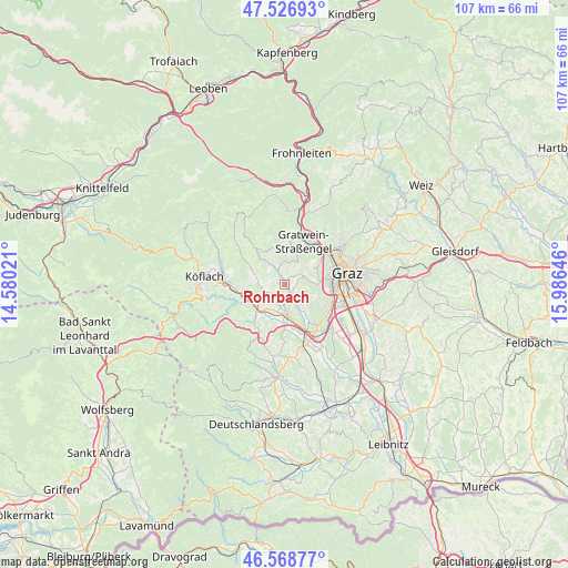
Rohrbach GPS coordinates[2]
47° 3' 0" North, 15° 16' 59.988" East
| Map corner | latitude | longitude |
|---|---|---|
| Upper-left | 47.52693°, | 14.58021° |
| Center: | 47.05°, | 15.28333° |
| Lower-right: | 46.56877°, | 15.98646° |
| Map W x H: | 106.5×106.5 km | = 66.2×66.2mi |
| max Lat: | 48.98333° ⇑82.2% North |
| Rohrbach: | 47.05° |
| min Lat: | ⇓17.8% South 46.48841° |
| min Long | Rohrbach | max Long |
| 9.57802° | 15.28333° | 17.1° |
| W 59.7%⇐ | ⇒40.3% E |
Elevation
Elevation of Rohrbach is 389 m = 1276 ft, and this is 116.5 m = 382 ft below average elevation for this country.
| Max E: |
2140 m = 7021 ft | 59.4% |
| Avg. | 505.5 m = 1658 ft | |
| Rohrbach | 389 m = 1276 ft | |
Min E: |
118 m = 387 ft | 40.6% |
See also: Austria elevation on elevation.city.
Geographical zone
Rohrbach is located in North temperate zone (between Tropic of Cancer and the Arctic Circle). Distance of this North polar circle is 2169.7 km =1348.2 mi to North.| Distance of | km | miles | from Rohrbach |
|---|---|---|---|
| North Pole | 4775.6 | 2967.4 | to North |
| Arctic Circle | 2169.7 | 1348.2 | to North |
| Tropic Cancer | 2625.6 | 1631.5 | to South |
| Equator | 5231.5 | 3250.7 | to South |


Nearby cities:
15 places around Rohrbach: (largest is in red/bold)
• Attendorf
6.6 km =4.1 mi,  140°
140°
• Grosssöding
5.7 km =3.5 mi,  167°
167°
• Hitzendorf
2.2 km =1.4 mi,  145°
145°
• Jaritzberg
4.5 km =2.8 mi,  325°
325°
• Kleingaisfeld
6.2 km =3.9 mi,  243°
243°
• Kleinsöding
5.6 km =3.5 mi,  180°
180°
• Krottendorf bei Ligist
6.3 km =3.9 mi,  233°
233°
• Pichling bei Mooskirchen
3.9 km =2.4 mi,  198°
198°
• Plankenwarth
4.9 km =3 mi,  26°
26°
• Sankt Bartholomä
1.9 km =1.2 mi,  285°
285°
• Sankt Oswald bei Plankenwarth
4.1 km =2.5 mi,  353°
353°
• Stallhofen
5.1 km =3.2 mi,  270°
270°
• Steinberg
3.1 km =1.9 mi,  53°
53°
• Stiwoll
7.5 km =4.7 mi,  317°
317°
• Thal
6.5 km =4 mi,  63°
63°
Sources, notices
• [Note1] Compared only with cities in Austria existing in our database
• [Src1] Map data: © OpenStreetMap contributors (CC-BY-SA)
• [Src2] Other city data from geonames.org with taken over terms of usage.
• [Src3] Geographical zone / Annual Mean Temperature by Robert A. Rohde @ Wikipedia
