Kitzbühel geodata
Kitzbühel (Tyrol) is a seat of a third-order administrative division; located in Austria in Europe/Vienna (GMT+2) time zone. With population of 8,272 people, there are 107 cities with bigger population in this country. Compared to other cities in Austria, 56.9% of cities are located further ↑North; 86.7% of cities are located further →East and 82% of cities have lower elevation than Kitzbühel. Note1


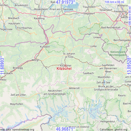
Kitzbühel GPS coordinates[2]
47° 26' 46.932" North, 12° 23' 31.74" East
| Map corner | latitude | longitude |
|---|---|---|
| Upper-left | 47.91973°, | 11.68903° |
| Center: | 47.44637°, | 12.39215° |
| Lower-right: | 46.96871°, | 13.09528° |
| Map W x H: | 105.7×105.7 km | = 65.7×65.7mi |
| max Lat: | 48.98333° ⇑56.9% North |
| Kitzbühel: | 47.44637° |
| min Lat: | ⇓43.1% South 46.48841° |
| min Long | Kitzbühel | max Long |
| 9.57802° | 12.39215° | 17.1° |
| W 13.3%⇐ | ⇒86.7% E |
Elevation
Elevation of Kitzbühel is 751 m = 2464 ft, and this is 245.5 m = 805 ft above average elevation for this country.
| Max E: |
2140 m = 7021 ft | 18% |
| Kitzbühel | 751 m 2464 ft | |
| Avg. | 505.5 m = 1658 ft | |
Min E: |
118 m = 387 ft | 82% |
See also: Austria elevation on elevation.city.
Geographical zone
Kitzbühel is located in North temperate zone (between Tropic of Cancer and the Arctic Circle). Distance of this North polar circle is 2125.6 km =1320.8 mi to North.| Distance of | km | miles | from Kitzbühel |
|---|---|---|---|
| North Pole | 4731.5 | 2940 | to North |
| Arctic Circle | 2125.6 | 1320.8 | to North |
| Tropic Cancer | 2669.6 | 1658.8 | to South |
| Equator | 5275.5 | 3278 | to South |


Nearby cities:
15 places around Kitzbühel: (largest is in red/bold)
• Aurach
4.6 km =2.9 mi,  145°
145°
• Brixen im Thale
10.7 km =6.6 mi,  272°
272°
• Ellmau
10.2 km =6.3 mi,  317°
317°
• Fieberbrunn
11.9 km =7.4 mi,  73°
73°
• Going
8.7 km =5.4 mi,  328°
328°
• Jochberg
7.7 km =4.8 mi,  165°
165°
• Kirchberg in Tirol
5.7 km =3.5 mi, 268°
• Kirchdorf in Tirol
12.8 km =8 mi,  18°
18°
• Oberndorf in Tirol
6 km =3.7 mi,  353°
353°
• Reith bei Kitzbühel
3.9 km =2.4 mi,  305°
305°
• Sankt Jakob in Haus
13.3 km =8.3 mi,  63°
63°
• Sankt Johann in Tirol
8.9 km =5.5 mi, 15°
• Scheffau am Wilden Kaiser
14 km =8.7 mi, 311°
• Sonnseite
10.2 km =6.3 mi, 323°
• Westendorf
13.5 km =8.4 mi,  263°
263°
Sources, notices
• [Note1] Compared only with cities in Austria existing in our database
• [Src1] Map data: © OpenStreetMap contributors (CC-BY-SA)
• [Src2] Other city data from geonames.org with taken over terms of usage.
• [Src3] Geographical zone / Annual Mean Temperature by Robert A. Rohde @ Wikipedia
