Fieberbrunn geodata
Fieberbrunn (Tyrol) is a seat of a third-order administrative division; located in Austria in Europe/Vienna (GMT+2) time zone. With population of 4,287 people, there are 236 cities with bigger population in this country. Compared to other cities in Austria, 55% of cities are located further ↑North; 85.9% of cities are located further →East and 83.6% of cities have lower elevation than Fieberbrunn. Note1
Administrative division(s):
- Level 1: Tyrol
- Level 2: Politischer Bezirk Kitzbühel
- Level 3: Fieberbrunn


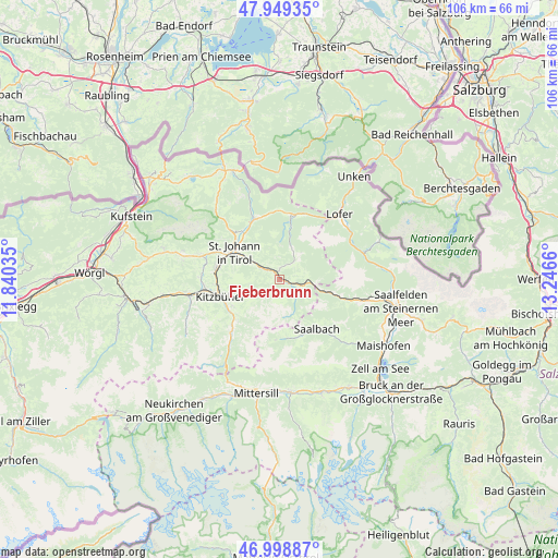
Fieberbrunn GPS coordinates[2]
47° 28' 34.536" North, 12° 32' 36.492" East
| Map corner | latitude | longitude |
|---|---|---|
| Upper-left | 47.94935°, | 11.84035° |
| Center: | 47.47626°, | 12.54347° |
| Lower-right: | 46.99887°, | 13.2466° |
| Map W x H: | 105.7×105.7 km | = 65.7×65.7mi |
| max Lat: | 48.98333° ⇑55% North |
| Fieberbrunn: | 47.47626° |
| min Lat: | ⇓45% South 46.48841° |
| min Long | Fieberbrunn | max Long |
| 9.57802° | 12.54347° | 17.1° |
| W 14.1%⇐ | ⇒85.9% E |
Elevation
Elevation of Fieberbrunn is 777 m = 2549 ft, and this is 271.5 m = 891 ft above average elevation for this country.
| Max E: |
2140 m = 7021 ft | 16.4% |
| Fieberbrunn | 777 m 2549 ft | |
| Avg. | 505.5 m = 1658 ft | |
Min E: |
118 m = 387 ft | 83.6% |
See also: Austria elevation on elevation.city.
Geographical zone
Fieberbrunn is located in North temperate zone (between Tropic of Cancer and the Arctic Circle). Distance of this North polar circle is 2122.3 km =1318.7 mi to North.| Distance of | km | miles | from Fieberbrunn |
|---|---|---|---|
| North Pole | 4728.2 | 2938 | to North |
| Arctic Circle | 2122.3 | 1318.7 | to North |
| Tropic Cancer | 2672.9 | 1660.9 | to South |
| Equator | 5278.9 | 3280.2 | to South |


Nearby cities:
15 places around Fieberbrunn: (largest is in red/bold)
• Aurach
11.3 km =7 mi,  230°
230°
• Erpfendorf
13.2 km =8.2 mi,  334°
334°
• Hinterglemm
11.7 km =7.3 mi,  160°
160°
• Hochfilzen
5.6 km =3.5 mi,  100°
100°
• Jochberg
14.3 km =8.9 mi,  221°
221°
• Kirchdorf in Tirol
11.6 km =7.2 mi,  320°
320°
• Kitzbühel
11.9 km =7.4 mi,  253°
253°
• Oberndorf in Tirol
12.3 km =7.6 mi,  282°
282°
• Reith bei Kitzbühel
14.6 km =9.1 mi,  265°
265°
• Saalbach
11.7 km =7.3 mi,  143°
143°
• Sankt Jakob in Haus
2.7 km =1.7 mi,  10°
10°
• Sankt Johann in Tirol
10.4 km =6.5 mi,  300°
300°
• Sankt Ulrich am Pillersee
6.1 km =3.8 mi,  20°
20°
• Sonnberg
14.6 km =9.1 mi, 101°
• Waidring
12 km =7.5 mi, 8°
Sources, notices
• [Note1] Compared only with cities in Austria existing in our database
• [Src1] Map data: © OpenStreetMap contributors (CC-BY-SA)
• [Src2] Other city data from geonames.org with taken over terms of usage.
• [Src3] Geographical zone / Annual Mean Temperature by Robert A. Rohde @ Wikipedia
