Hohenweiler geodata
Hohenweiler (Vorarlberg) is a seat of a third-order administrative division; located in Austria in Europe/Vienna (GMT+2) time zone. With population of 1,271 people, there are 992 cities with bigger population in this country. Compared to other cities in Austria, 50.4% of cities are located further ↑North; 98.4% of cities are located further →East and 59.7% of cities have lower elevation than Hohenweiler. Note1
Administrative division(s):
- Level 1: Vorarlberg
- Level 2: Politischer Bezirk Bregenz
- Level 3: Hohenweiler


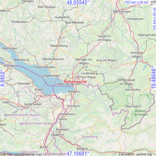
Hohenweiler GPS coordinates[2]
47° 34' 59.988" North, 9° 46' 59.988" East
| Map corner | latitude | longitude |
|---|---|---|
| Upper-left | 48.05545°, | 9.0802° |
| Center: | 47.58333°, | 9.78333° |
| Lower-right: | 47.10691°, | 10.48646° |
| Map W x H: | 105.5×105.5 km | = 65.6×65.6mi |
| max Lat: | 48.98333° ⇑50.4% North |
| Hohenweiler: | 47.58333° |
| min Lat: | ⇓49.6% South 46.48841° |
| min Long | Hohenweiler | max Long |
| 9.57802° | 9.78333° | 17.1° |
| W 1.6%⇐ | ⇒98.4% E |
Elevation
Elevation of Hohenweiler is 516 m = 1693 ft, and this is 10.5 m = 34 ft above average elevation for this country.
| Max E: |
2140 m = 7021 ft | 40.3% |
| Hohenweiler | 516 m 1693 ft | |
| Avg. | 505.5 m = 1658 ft | |
Min E: |
118 m = 387 ft | 59.7% |
See also: Austria elevation on elevation.city.
Geographical zone
Hohenweiler is located in North temperate zone (between Tropic of Cancer and the Arctic Circle). Distance of this North polar circle is 2110.4 km =1311.3 mi to North.| Distance of | km | miles | from Hohenweiler |
|---|---|---|---|
| North Pole | 4716.3 | 2930.6 | to North |
| Arctic Circle | 2110.4 | 1311.3 | to North |
| Tropic Cancer | 2684.9 | 1668.3 | to South |
| Equator | 5290.8 | 3287.5 | to South |


Nearby cities:
15 places around Hohenweiler: (largest is in red/bold)
• Bildstein
14.9 km =9.3 mi,  184°
184°
• Bregenz
9.3 km =5.8 mi,  196°
196°
• Buch
11.2 km =7 mi,  165°
165°
• Doren
12.4 km =7.7 mi,  144°
144°
• Eichenberg
5.6 km =3.5 mi, 180°
• Fußach
14.7 km =9.1 mi,  218°
218°
• Hard
13.5 km =8.4 mi,  214°
214°
• Hörbranz
4.5 km =2.8 mi, 214°
• Kennelbach
11.2 km =7 mi,  186°
186°
• Langen
7.8 km =4.8 mi,  161°
161°
• Lauterach
12.6 km =7.8 mi, 198°
• Lochau
6.1 km =3.8 mi, 204°
• Möggers
3.1 km =1.9 mi,  126°
126°
• Sulzberg
11.9 km =7.4 mi, 125°
• Wolfurt
13.2 km =8.2 mi, 190°
Sources, notices
• [Note1] Compared only with cities in Austria existing in our database
• [Src1] Map data: © OpenStreetMap contributors (CC-BY-SA)
• [Src2] Other city data from geonames.org with taken over terms of usage.
• [Src3] Geographical zone / Annual Mean Temperature by Robert A. Rohde @ Wikipedia
