Doren geodata
Doren (Vorarlberg) is a seat of a third-order administrative division; located in Austria in Europe/Vienna (GMT+2) time zone. With population of 1,029 people, there are 1247 cities with bigger population in this country. Compared to other cities in Austria, 54% of cities are located further ↑North; 97.8% of cities are located further →East and 79.5% of cities have lower elevation than Doren. Note1


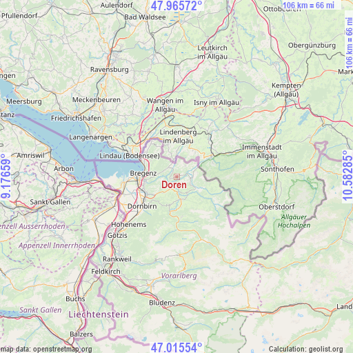
Doren GPS coordinates[2]
47° 29' 34.008" North, 9° 52' 46.992" East
| Map corner | latitude | longitude |
|---|---|---|
| Upper-left | 47.96572°, | 9.17659° |
| Center: | 47.49278°, | 9.87972° |
| Lower-right: | 47.01554°, | 10.58285° |
| Map W x H: | 105.7×105.6 km | = 65.7×65.6mi |
| max Lat: | 48.98333° ⇑54% North |
| Doren: | 47.49278° |
| min Lat: | ⇓46% South 46.48841° |
| min Long | Doren | max Long |
| 9.57802° | 9.87972° | 17.1° |
| W 2.2%⇐ | ⇒97.8% E |
Elevation
Elevation of Doren is 706 m = 2316 ft, and this is 200.5 m = 658 ft above average elevation for this country.
| Max E: |
2140 m = 7021 ft | 20.5% |
| Doren | 706 m 2316 ft | |
| Avg. | 505.5 m = 1658 ft | |
Min E: |
118 m = 387 ft | 79.5% |
See also: Austria elevation on elevation.city.
Geographical zone
Doren is located in North temperate zone (between Tropic of Cancer and the Arctic Circle). Distance of this North polar circle is 2120.5 km =1317.6 mi to North.| Distance of | km | miles | from Doren |
|---|---|---|---|
| North Pole | 4726.4 | 2936.8 | to North |
| Arctic Circle | 2120.5 | 1317.6 | to North |
| Tropic Cancer | 2674.8 | 1662 | to South |
| Equator | 5280.7 | 3281.3 | to South |


Nearby cities:
15 places around Doren: (largest is in red/bold)
• Alberschwende
6 km =3.7 mi,  217°
217°
• Andelsbuch
9.1 km =5.7 mi,  173°
173°
• Buch
4.5 km =2.8 mi,  259°
259°
• Egg
6.9 km =4.3 mi, 168°
• Eichenberg
8.5 km =5.3 mi,  301°
301°
• Großdorf
7.1 km =4.4 mi,  157°
157°
• Hittisau
7.2 km =4.5 mi,  122°
122°
• Kennelbach
8.6 km =5.3 mi, 262°
• Krumbach
4.4 km =2.7 mi,  104°
104°
• Langen
5.4 km =3.4 mi, 299°
• Langenegg
2.9 km =1.8 mi,  153°
153°
• Lingenau
5.7 km =3.5 mi, 146°
• Riefensberg
6 km =3.7 mi,  80°
80°
• Schwarzenberg
9 km =5.6 mi,  193°
193°
• Sulzberg
4.1 km =2.5 mi,  38°
38°
Sources, notices
• [Note1] Compared only with cities in Austria existing in our database
• [Src1] Map data: © OpenStreetMap contributors (CC-BY-SA)
• [Src2] Other city data from geonames.org with taken over terms of usage.
• [Src3] Geographical zone / Annual Mean Temperature by Robert A. Rohde @ Wikipedia
