Hohenau an der Raab geodata
Hohenau an der Raab (Styria) is a seat of a third-order administrative division; located in Austria in Europe/Vienna (GMT+2) time zone. With population of 492 people, there are 2517 cities with bigger population in this country. Compared to other cities in Austria, 65.5% of cities are located further ↑North; 66.8% of cities are located further ←West and 87.4% of cities have lower elevation than Hohenau an der Raab. Note1


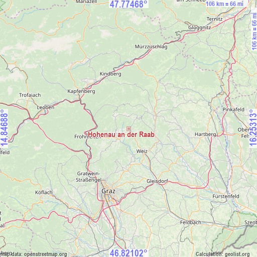
Hohenau an der Raab GPS coordinates[2]
47° 18' 0" North, 15° 33' 0" East
| Map corner | latitude | longitude |
|---|---|---|
| Upper-left | 47.77468°, | 14.84688° |
| Center: | 47.3°, | 15.55° |
| Lower-right: | 46.82102°, | 16.25313° |
| Map W x H: | 106×106 km | = 65.9×65.9mi |
| max Lat: | 48.98333° ⇑65.5% North |
| Hohenau an der Raab: | 47.3° |
| min Lat: | ⇓34.5% South 46.48841° |
| min Long | Hohenau an der | max Long |
| 9.57802° | 15.55° | 17.1° |
| W 66.8%⇐ | ⇒33.2% E |
Elevation
Elevation of Hohenau an der Raab is 835 m = 2740 ft, and this is 329.5 m = 1081 ft above average elevation for this country.
| Max E: |
2140 m = 7021 ft | 12.6% |
| Hohenau an der Raab | 835 m 2740 ft | |
| Avg. | 505.5 m = 1658 ft | |
Min E: |
118 m = 387 ft | 87.4% |
See also: Austria elevation on elevation.city.
Geographical zone
Hohenau an der Raab is located in North temperate zone (between Tropic of Cancer and the Arctic Circle). Distance of this North polar circle is 2141.9 km =1330.9 mi to North.| Distance of | km | miles | from Hohenau an der Raab |
|---|---|---|---|
| North Pole | 4747.8 | 2950.1 | to North |
| Arctic Circle | 2141.9 | 1330.9 | to North |
| Tropic Cancer | 2653.3 | 1648.7 | to South |
| Equator | 5259.3 | 3268 | to South |


Nearby cities:
15 places around Hohenau an der Raab: (largest is in red/bold)
• Affental
7.2 km =4.5 mi,  157°
157°
• Anger
11 km =6.8 mi,  105°
105°
• Arzberg
6.1 km =3.8 mi,  204°
204°
• Fladnitz an der Teichalm
5.7 km =3.5 mi,  253°
253°
• Gasen
9.4 km =5.8 mi,  7°
7°
• Göttelsberg
10 km =6.2 mi, 157°
• Landscha bei Weiz
10.5 km =6.5 mi,  151°
151°
• Mortantsch
10.5 km =6.5 mi,  167°
167°
• Naas
6.4 km =4 mi, 148°
• Passail
3.1 km =1.9 mi,  233°
233°
• Sankt Kathrein am Offenegg
2.5 km =1.6 mi,  90°
90°
• Sankt Kathrein am Offenegg I Viertel
2.5 km =1.6 mi,  96°
96°
• Sankt Kathrein am Offenegg II Viertel
3.3 km =2.1 mi,  23°
23°
• Stenzengreith
11.4 km =7.1 mi,  192°
192°
• Weiz
10.5 km =6.5 mi, 151°
Sources, notices
• [Note1] Compared only with cities in Austria existing in our database
• [Src1] Map data: © OpenStreetMap contributors (CC-BY-SA)
• [Src2] Other city data from geonames.org with taken over terms of usage.
• [Src3] Geographical zone / Annual Mean Temperature by Robert A. Rohde @ Wikipedia
