Haringsee geodata
Haringsee (Lower Austria) is a seat of a third-order administrative division; located in Austria in Europe/Vienna (GMT+2) time zone. With population of 673 people, there are 1921 cities with bigger population in this country. Compared to other cities in Austria, 78.8% of cities are located further ↓South; 98.2% of cities are located further ←West and 99% of cities have higher elevation than Haringsee. Note1
Administrative division(s):
- Level 1: Lower Austria
- Level 2: Politischer Bezirk Gänserndorf
- Level 3: Haringsee


Haringsee GPS coordinates[2]
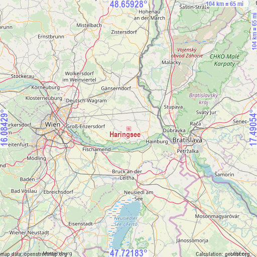
48° 11' 33.72" North, 16° 47' 14.676" East
| Map corner | latitude | longitude |
|---|---|---|
| Upper-left | 48.65928°, | 16.08429° |
| Center: | 48.1927°, | 16.78741° |
| Lower-right: | 47.72183°, | 17.49054° |
| Map W x H: | 104.2×104.2 km | = 64.7×64.7mi |
| max Lat: | 48.98333° ⇑21.2% North |
| Haringsee: | 48.1927° |
| min Lat: | ⇓78.8% South 46.48841° |
| min Long | Haringsee | max Long |
| 9.57802° | 16.78741° | 17.1° |
| W 98.2%⇐ | ⇒1.8% E |
Elevation
Elevation of Haringsee is 144 m = 472 ft, and this is 361.5 m = 1186 ft below average elevation for this country.
| Max E: |
2140 m = 7021 ft | 99% |
| Avg. | 505.5 m = 1658 ft | |
| Haringsee | 144 m = 472 ft | |
Min E: |
118 m = 387 ft | 1% |
See also: Austria elevation on elevation.city.
Geographical zone
Haringsee is located in North temperate zone (between Tropic of Cancer and the Arctic Circle). Distance of this North polar circle is 2042.6 km =1269.2 mi to North.| Distance of | km | miles | from Haringsee |
|---|---|---|---|
| North Pole | 4648.5 | 2888.4 | to North |
| Arctic Circle | 2042.6 | 1269.2 | to North |
| Tropic Cancer | 2752.6 | 1710.4 | to South |
| Equator | 5358.5 | 3329.6 | to South |


Nearby cities:
15 places around Haringsee: (largest is in red/bold)
• Andlersdorf
9 km =5.6 mi,  263°
263°
• Bad Deutsch-Altenburg
11 km =6.8 mi,  126°
126°
• Breitensee
8.9 km =5.5 mi,  49°
49°
• Eckartsau
5.3 km =3.3 mi,  172°
172°
• Engelhartstetten
7.2 km =4.5 mi,  99°
99°
• Haslau an der Donau
9.9 km =6.2 mi,  211°
211°
• Lassee
4.4 km =2.7 mi,  35°
35°
• Leopoldsdorf im Marchfelde
8 km =5 mi,  294°
294°
• Mannsdorf an der Donau
10.1 km =6.3 mi,  243°
243°
• Marchegg
11.9 km =7.4 mi, 49°
• Obersiebenbrunn
9.9 km =6.2 mi,  324°
324°
• Orth an der Donau
8.3 km =5.2 mi,  230°
230°
• Petronell-Carnuntum
10.6 km =6.6 mi,  146°
146°
• Scharndorf
11 km =6.8 mi,  175°
175°
• Untersiebenbrunn
7.5 km =4.7 mi,  327°
327°
Sources, notices
• [Note1] Compared only with cities in Austria existing in our database
• [Src1] Map data: © OpenStreetMap contributors (CC-BY-SA)
• [Src2] Other city data from geonames.org with taken over terms of usage.
• [Src3] Geographical zone / Annual Mean Temperature by Robert A. Rohde @ Wikipedia
