Lassee geodata
Lassee (Lower Austria) is a seat of a third-order administrative division; located in Austria in Europe/Vienna (GMT+2) time zone. With population of 2,379 people, there are 514 cities with bigger population in this country. Compared to other cities in Austria, 81% of cities are located further ↓South; 98.5% of cities are located further ←West and 99% of cities have higher elevation than Lassee. Note1
Administrative division(s):
- Level 1: Lower Austria
- Level 2: Politischer Bezirk Gänserndorf
- Level 3: Lassee


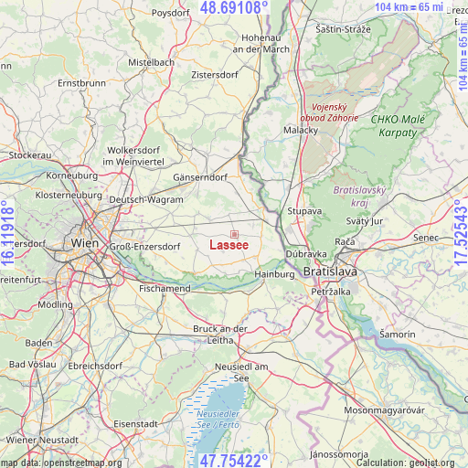
Lassee GPS coordinates[2]
48° 13' 29.244" North, 16° 49' 20.28" East
| Map corner | latitude | longitude |
|---|---|---|
| Upper-left | 48.69108°, | 16.11918° |
| Center: | 48.22479°, | 16.8223° |
| Lower-right: | 47.75422°, | 17.52543° |
| Map W x H: | 104.2×104.2 km | = 64.7×64.7mi |
| max Lat: | 48.98333° ⇑19% North |
| Lassee: | 48.22479° |
| min Lat: | ⇓81% South 46.48841° |
| min Long | Lassee | max Long |
| 9.57802° | 16.8223° | 17.1° |
| W 98.5%⇐ | ⇒1.5% E |
Elevation
Elevation of Lassee is 144 m = 472 ft, and this is 361.5 m = 1186 ft below average elevation for this country.
| Max E: |
2140 m = 7021 ft | 99% |
| Avg. | 505.5 m = 1658 ft | |
| Lassee | 144 m = 472 ft | |
Min E: |
118 m = 387 ft | 1% |
See also: Austria elevation on elevation.city.
Geographical zone
Lassee is located in North temperate zone (between Tropic of Cancer and the Arctic Circle). Distance of this North polar circle is 2039.1 km =1267 mi to North.| Distance of | km | miles | from Lassee |
|---|---|---|---|
| North Pole | 4645 | 2886.3 | to North |
| Arctic Circle | 2039.1 | 1267 | to North |
| Tropic Cancer | 2756.2 | 1712.6 | to South |
| Equator | 5362.1 | 3331.9 | to South |


Nearby cities:
15 places around Lassee: (largest is in red/bold)
• Andlersdorf
12.4 km =7.7 mi,  248°
248°
• Bad Deutsch-Altenburg
11.8 km =7.3 mi,  148°
148°
• Breitensee
4.7 km =2.9 mi,  62°
62°
• Eckartsau
9.1 km =5.7 mi,  191°
191°
• Engelhartstetten
6.6 km =4.1 mi,  136°
136°
• Glinzendorf
13.7 km =8.5 mi,  279°
279°
• Hainburg an der Donau
12.6 km =7.8 mi,  133°
133°
• Haringsee
4.4 km =2.7 mi,  215°
215°
• Leopoldsdorf im Marchfelde
9.9 km =6.2 mi,  268°
268°
• Marchegg
7.7 km =4.8 mi, 57°
• Obersiebenbrunn
9.4 km =5.8 mi,  298°
298°
• Orth an der Donau
12.6 km =7.8 mi,  225°
225°
• Petronell-Carnuntum
12.8 km =8 mi,  165°
165°
• Untersiebenbrunn
7.2 km =4.5 mi,  293°
293°
• Weikendorf
13.9 km =8.6 mi,  342°
342°
Sources, notices
• [Note1] Compared only with cities in Austria existing in our database
• [Src1] Map data: © OpenStreetMap contributors (CC-BY-SA)
• [Src2] Other city data from geonames.org with taken over terms of usage.
• [Src3] Geographical zone / Annual Mean Temperature by Robert A. Rohde @ Wikipedia
