Gusswerk geodata
Gusswerk (Styria) is a populated place; located in Austria in Europe/Vienna (GMT+2) time zone. With population of 866 people, there are 1490 cities with bigger population in this country. Compared to other cities in Austria, 55.3% of cities are located further ↓South; 60.3% of cities are located further ←West and 81% of cities have lower elevation than Gusswerk. Note1
Administrative division(s):
- Level 1: Styria
- Level 2: Politischer Bezirk Bruck-Mürzzuschlag
- Level 3: Mariazell


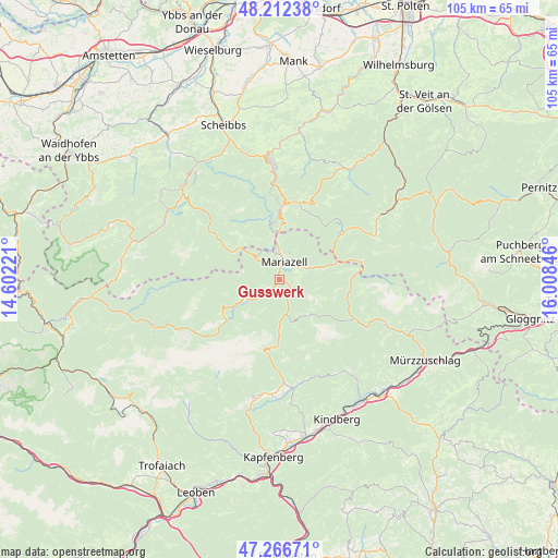
Gusswerk GPS coordinates[2]
47° 44' 30.084" North, 15° 18' 19.188" East
| Map corner | latitude | longitude |
|---|---|---|
| Upper-left | 48.21238°, | 14.60221° |
| Center: | 47.74169°, | 15.30533° |
| Lower-right: | 47.26671°, | 16.00846° |
| Map W x H: | 105.1×105.1 km | = 65.3×65.3mi |
| max Lat: | 48.98333° ⇑44.7% North |
| Gusswerk: | 47.74169° |
| min Lat: | ⇓55.3% South 46.48841° |
| min Long | Gusswerk | max Long |
| 9.57802° | 15.30533° | 17.1° |
| W 60.3%⇐ | ⇒39.7% E |
Elevation
Elevation of Gusswerk is 737 m = 2418 ft, and this is 231.5 m = 760 ft above average elevation for this country.
| Max E: |
2140 m = 7021 ft | 19% |
| Gusswerk | 737 m 2418 ft | |
| Avg. | 505.5 m = 1658 ft | |
Min E: |
118 m = 387 ft | 81% |
See also: Austria elevation on elevation.city.
Geographical zone
Gusswerk is located in North temperate zone (between Tropic of Cancer and the Arctic Circle). Distance of this North polar circle is 2092.8 km =1300.4 mi to North.| Distance of | km | miles | from Gusswerk |
|---|---|---|---|
| North Pole | 4698.7 | 2919.6 | to North |
| Arctic Circle | 2092.8 | 1300.4 | to North |
| Tropic Cancer | 2702.5 | 1679.3 | to South |
| Equator | 5308.4 | 3298.5 | to South |


Nearby cities:
15 places around Gusswerk: (largest is in red/bold)
• Aflenz Kurort
22.7 km =14.1 mi,  192°
192°
• Alpl
20.6 km =12.8 mi,  108°
108°
• Annaberg
15.4 km =9.6 mi,  20°
20°
• Grossveitsch
21.1 km =13.1 mi,  143°
143°
• Mariazell
3.6 km =2.2 mi,  13°
13°
• Mitterbach am Erlaufsee
8.1 km =5 mi,  354°
354°
• Mürzsteg
15.7 km =9.8 mi,  117°
117°
• Neuberg an der Mürz
21.8 km =13.5 mi, 113°
• Puchenstuben
20.8 km =12.9 mi,  356°
356°
• Sankt Aegyd am Neuwalde
23.4 km =14.5 mi,  57°
57°
• Sankt Ilgen
23.7 km =14.7 mi,  205°
205°
• Schwarzenbach an der Pielach
22.1 km =13.7 mi, 15°
• St. Sebastian
4.6 km =2.9 mi,  3°
3°
• Turnau
20.6 km =12.8 mi,  173°
173°
• Veitsch
23.1 km =14.4 mi, 142°
Sources, notices
• [Note1] Compared only with cities in Austria existing in our database
• [Src1] Map data: © OpenStreetMap contributors (CC-BY-SA)
• [Src2] Other city data from geonames.org with taken over terms of usage.
• [Src3] Geographical zone / Annual Mean Temperature by Robert A. Rohde @ Wikipedia
